Kenner, Louisiana Map and Directory
Regional Directory > States Menu > Louisiana
 According to the United States Census Bureau, Kenner is a City that is located in Jefferson Parish, Louisiana at 29.99 degrees North and 90.24 degrees West.
The city's time zone is America/Chicago, and the city's primary telephone area code is 504.
The land area of Kenner is about 14.87 square miles, whereas the water area of the city is about 0.24 square miles.
Jefferson Parish's land area is about 296 square miles, so the city occupies about 5.0 percent of the county's total land area.
According to the United States Census Bureau, Kenner is a City that is located in Jefferson Parish, Louisiana at 29.99 degrees North and 90.24 degrees West.
The city's time zone is America/Chicago, and the city's primary telephone area code is 504.
The land area of Kenner is about 14.87 square miles, whereas the water area of the city is about 0.24 square miles.
Jefferson Parish's land area is about 296 square miles, so the city occupies about 5.0 percent of the county's total land area.
The Census Bureau estimates that Kenner had about 66,340 residents in 2019, which is approximately 4,461 people per square mile of land area.
According to recent American Community Survey data, the median household income in Kenner was about $54,975 per year.
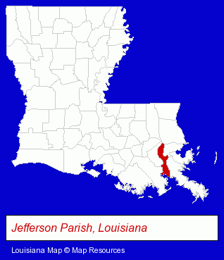
The Louisiana counties map at upper right shows Jefferson Parish, highlighted in red. Use the menu below to display interactive maps of Kenner, either in a frame on this page or in full-screen mode.
Use the menu below to display categorized Kenner directories.
| Kenner Products and Services Directory | ||
|---|---|---|
| Attorneys | Auto Dealers | Auto Service |
| Building Contractors | Freight Forwarding | Home Improvement |
| Movers | Physicians | Printing and Publishing |
| Visual Arts | ||
Selected Kenner, Louisiana Listings
These randomly selected Kenner listings provide some insight into the city's cultural environment and economic climate.- Special Trades Contractors
- Concrete Contractors
- Concrete Repair & Restoration Contractors
- Concrete Breaking, Coring, Cutting, Drilling & Sawing
- Trucking Companies
- Towing
- Freight Forwarding
- Heavy Duty Trucking
- Machinery Movers & Erectors
- Furniture Stores
- Bedroom Furniture
- Mattresses Retail
- Beds Retail
- Factory Outlets
- Personal Injury Attorneys
- Criminal Law Attorneys
- Family Law Attorneys
- Estate Planning & Administration Attorneys
- Bridal Shops & Services
- Fabric Shops
- Alterations & Tailoring
- Masquerade & Theatrical Costumes Sales & Rental
- Costumes
- Pest Control Services
- Lawn Mowers Retail
- Lawn Mower Sharpening & Repair
- Coffee & Tea Shops
- Medical Equipment & Supplies Retail
- Medical Equipment & Supplies Wholesale & Manufacturers
- Surgical Instruments Wholesale & Manufacturers
- Auto Body Repair & Painting
- Dentists
- Government Contractors
- Machine Shops
- Welding Services
- Auto Parts Retail
- Auto Dealers
- Truck Dealers
- Used Cars
- Paving Contractors
- Paving Materials
- Concrete Contractors
- Construction Machinery & Equipment Dealers
- Concrete Construction Equipment & Supplies
- Concrete Pumping Service & Equipment
- Mini & Self Storage
- Mini & Self Storage Warehouses
- Self Service Moving & Storage
- Collection Agencies
Nearby Louisiana Cities and Towns *
- Chalmette (2) - Chalmette, Louisiana information and maps.
- Gretna (4) - Gretna, Louisiana information and maps.
- Harahan (1) - Harahan, Louisiana information and maps.
- Harvey (5) - Harvey, Louisiana demographics and maps.
- Marrero (3) - Marrero, Louisiana information and maps.
- Metairie (48) - Metairie, Louisiana products & services directory.
- New Orleans (76) - New Orleans, Louisiana products & services directory.
* Parenthesized numbers indicate economic activity levels.
Copyright © 2011-2026 RegionalDirectory.us. All rights reserved.