Hampstead, Maryland Map and Directory
Regional Directory > States Menu > Maryland
 According to the United States Census Bureau, Hampstead is a Town that is located in Carroll County, Maryland at 39.60 degrees North and 76.85 degrees West.
The town's time zone is America/New York, and the town's primary telephone area code is 410.
The land area of Hampstead is about 3.25 square miles, whereas the water area of the town is about 0.03 square miles.
Carroll County's land area is about 448 square miles, so the town occupies about 0.7 percent of the county's total land area.
According to the United States Census Bureau, Hampstead is a Town that is located in Carroll County, Maryland at 39.60 degrees North and 76.85 degrees West.
The town's time zone is America/New York, and the town's primary telephone area code is 410.
The land area of Hampstead is about 3.25 square miles, whereas the water area of the town is about 0.03 square miles.
Carroll County's land area is about 448 square miles, so the town occupies about 0.7 percent of the county's total land area.
The Census Bureau estimates that Hampstead had about 6,401 residents in 2019, which is approximately 1,970 people per square mile of land area.
According to recent American Community Survey data, the median household income in Hampstead was about $77,083 per year.
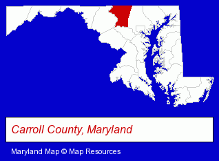
The Maryland counties map at upper right shows Carroll County, highlighted in red. Use the menu below to display interactive maps of Hampstead, either in a frame on this page or in full-screen mode.
Use the menu below to display categorized Hampstead directories.
| Hampstead Directory Page: | Metals |
|---|
Selected Hampstead, Maryland Listings
These Hampstead listings provide some insight into the town's cultural environment and economic climate.- Building & Home Construction
- Building Materials & Supplies Dealers
- Building Remodeling & Repair Contractors
- Cabinet Dealers
- Industrial Equipment & Supplies Wholesale & Manufacturers
- Tool & Die Makers
- Restaurants
- Steak Restaurants
- Home Improvement & Maintenance
- Energy & Environment
- Recycling Services, Equipment & Supplies
- Waste Recycling Industrial
- Plumbing Equipment Rental
- Cosmetics Retail
- Perfumes & Colognes Retail
- Building Materials & Supplies Wholesale & Manufacturers
- Metal Products
- Metal Products Wholesale & Manufacturers
- Metal Products Dealers
- Sign Dealers
- Signs Wholesale & Manufacturers
- Building & Home Construction
- Special Trades Contractors
- Electric Contractors
- Electric Contractors Residential
- Pottery Retail
- Schools
- Elementary & Secondary Education
- Elementary Schools
- Moving & Storage
- Movers
Nearby Maryland Cities and Towns *
- Baltimore (45) - Baltimore, Maryland products & services directory.
- Catonsville (3) - Catonsville, Maryland information and maps.
- Ellicott City (4) - Ellicott City, Maryland information and maps.
- Owings Mills (7) - Owings Mills, Maryland demographics and maps.
- Sykesville (3) - Sykesville, Maryland information and maps.
- Towson (8) - Towson, Maryland demographics and maps.
- Westminster (10) - Westminster, Maryland demographics and directory.
* Parenthesized numbers indicate economic activity levels.
Copyright © 2011-2026 RegionalDirectory.us. All rights reserved.