Canton, Michigan Map and Directory
Regional Directory > States Menu > Michigan
 According to the United States Census Bureau, Canton is a Charter Township that is located in Wayne County, Michigan at 42.31 degrees North and 83.49 degrees West.
The township's time zone is America/Detroit, and the township's primary telephone area code is 734.
The land area of Canton is about 36.11 square miles, whereas the water area of the township is about 0.03 square miles.
Wayne County's land area is about 612 square miles, so the township occupies about 5.9 percent of the county's total land area.
According to the United States Census Bureau, Canton is a Charter Township that is located in Wayne County, Michigan at 42.31 degrees North and 83.49 degrees West.
The township's time zone is America/Detroit, and the township's primary telephone area code is 734.
The land area of Canton is about 36.11 square miles, whereas the water area of the township is about 0.03 square miles.
Wayne County's land area is about 612 square miles, so the township occupies about 5.9 percent of the county's total land area.
The Census Bureau estimates that Canton had about 89,701 residents in 2014, which is approximately 2,484 people per square mile of land area.
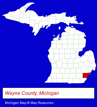
The Michigan counties map at upper right shows Wayne County, highlighted in red. Use the menu below to display interactive maps of Canton, either in a frame on this page or in full-screen mode.
Use the menu below to display categorized Canton directories.
| Canton Products and Services Directory | ||
|---|---|---|
| Building Materials | Business Services | Clinics |
| Dentists | Home Improvement | Schools |
Selected Canton, Michigan Listings
These randomly selected Canton listings provide some insight into the township's cultural environment and economic climate.- Veterinarians
- Animal Hospitals
- Animal Health
- Alternative Medicine
- Chiropractors
- Real Estate Commercial & Industrial
- Medical Equipment & Supplies Retail
- Electronic Equipment & Supplies Wholesale & Manufacturers
- Office Buildings & Parks
- Exporters
- Software Design & Development
- Commercial Air Conditioning Equipment & Systems
- Pet Care Services
- Pet Grooming & Boarding
- Pet Sitting & Day Care
- Commercial & Graphic Artists
- Religious Goods Stores
- Church Furnishings
- Used Cars
- Auto Parts Wholesale & Manufacturers
- Used & Rebuilt Auto Parts Retail
- Used & Rebuilt Auto Parts Wholesale & Manufacturers
- Alternative Medicine
- Beauty & Day Spas
- Skin Care Products
- Beauty Supplies & Equipment Retail
- Building & Home Construction
- Architects
- Architectural Services
Nearby Michigan Cities and Towns *
- Livonia (22) - Livonia, Michigan solutions directory and maps.
- Northville (4) - Northville, Michigan information and maps.
- Plymouth (5) - Plymouth, Michigan demographics and maps.
- Romulus (3) - Romulus, Michigan information and maps.
- Westland (4) - Westland, Michigan information and maps.
- Ypsilanti (7) - Ypsilanti, Michigan demographics and maps.
Large and Mid-size Cities in Nearby States
- Toledo, Ohio (35) - Toledo, OH solutions directory and maps.
* Parenthesized numbers indicate economic activity levels.
Copyright © 2011-2026 RegionalDirectory.us. All rights reserved.