Asheboro, North Carolina Map and Directory
Regional Directory > States Menu > North Carolina
 According to the United States Census Bureau, Asheboro is a City that is located in Randolph County, North Carolina at 35.71 degrees North and 79.81 degrees West.
The city's time zone is America/New York, and the city's primary telephone area code is 336.
The land area of Asheboro is about 18.80 square miles, whereas the water area of the city is about 0.09 square miles.
Randolph County's land area is about 783 square miles, so the city occupies about 2.4 percent of the county's total land area.
According to the United States Census Bureau, Asheboro is a City that is located in Randolph County, North Carolina at 35.71 degrees North and 79.81 degrees West.
The city's time zone is America/New York, and the city's primary telephone area code is 336.
The land area of Asheboro is about 18.80 square miles, whereas the water area of the city is about 0.09 square miles.
Randolph County's land area is about 783 square miles, so the city occupies about 2.4 percent of the county's total land area.
The Census Bureau estimates that Asheboro had about 25,940 residents in 2019, which is approximately 1,380 people per square mile of land area.
According to recent American Community Survey data, the median household income in Asheboro was about $38,211 per year.
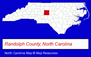
The North Carolina counties map at upper right shows Randolph County, highlighted in red. Use the menu below to display interactive maps of Asheboro, either in a frame on this page or in full-screen mode.
Use the menu below to display categorized Asheboro directories.
| Asheboro Products and Services Directory | ||
|---|---|---|
| Auto Service | Dentists | Information Technology |
| Insurance | Physicians | |
Selected Asheboro, North Carolina Listings
These randomly selected Asheboro listings provide some insight into the city's cultural environment and economic climate.- Restaurants
- Steak Restaurants
- Dermatology Physicians & Surgeons
- General Practice
- Florists
- Gift Shops
- Floral & Balloon Arrangements
- Artificial Flowers & Trees Retail
- Computer Consultants
- Computer Networks
- Campgrounds & RV Parks
- Camps
- Propane & Natural Gas
- Swimming Pool Equipment & Supplies
- Public & Private Swimming Pools
- Hotels
- Hotel & Motel Reservations
- Heating Contractors
- Air Conditioning Contractors
- Heating & Ventilating Contractors
- Auto Body Repair & Painting
- Endodontics Dentists
- Civic Clubs & Organizations
- Golf Courses
- Country Clubs
- Sports & Recreation Facilities
- Health Clubs & Gyms
- Recreation Centers
- Optometrists
- Optical Goods Retail
- Contact Lenses
Nearby North Carolina Cities and Towns *
- Burlington (15) - Burlington, North Carolina demographics and directory.
- Denton (2) - Denton, North Carolina information and maps.
- Greensboro (96) - Greensboro, North Carolina products & services directory.
- High Point (26) - High Point, North Carolina solutions directory and maps.
- Kernersville (4) - Kernersville, North Carolina information and maps.
- Lexington (4) - Lexington, North Carolina information and maps.
- Thomasville (1) - Thomasville, North Carolina information and maps.
* Parenthesized numbers indicate economic activity levels.
Copyright © 2011-2026 RegionalDirectory.us. All rights reserved.