Corvallis, Oregon Map and Directory
Regional Directory > States Menu > Oregon
 According to the United States Census Bureau, Corvallis is a City that is located in Benton County, Oregon at 44.56 degrees North and 123.26 degrees West.
The city's time zone is America/Los Angeles, and the city's primary telephone area code is 541.
The land area of Corvallis is about 14.24 square miles, whereas the water area of the city is about 0.13 square miles.
Benton County's land area is about 676 square miles, so the city occupies about 2.1 percent of the county's total land area.
According to the United States Census Bureau, Corvallis is a City that is located in Benton County, Oregon at 44.56 degrees North and 123.26 degrees West.
The city's time zone is America/Los Angeles, and the city's primary telephone area code is 541.
The land area of Corvallis is about 14.24 square miles, whereas the water area of the city is about 0.13 square miles.
Benton County's land area is about 676 square miles, so the city occupies about 2.1 percent of the county's total land area.
The Census Bureau estimates that Corvallis had about 58,856 residents in 2019, which is approximately 4,133 people per square mile of land area.
According to recent American Community Survey data, the median household income in Corvallis was about $52,942 per year.
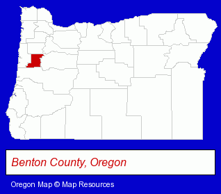
The Oregon counties map at upper right shows Benton County, highlighted in red. Use the menu below to display interactive maps of Corvallis, either in a frame on this page or in full-screen mode.
Use the menu below to display categorized Corvallis directories.
| Corvallis Products and Services Directory | ||
|---|---|---|
| Auto Service | Building Contractors | Civil Engineers |
| Clinics | Computer Printers | Dentists |
| Home Improvement | Information Technology | Landscape Contractors |
| Physicians | Restaurants | Schools |
| Veterinarians | Visual Arts | |
Selected Corvallis, Oregon Listings
These randomly selected Corvallis listings provide some insight into the city's cultural environment and economic climate.- Accountants
- Builders & Contractors
- Building Contractors
- Home Builders & Developers
- Homes & Residential Real Estate
- General Real Estate
- Real Estate Commercial & Industrial
- Real Estate Developers & Subdividers
- Real Estate Investments
- Orthodontics Dentists
- Mechanical Contractors
- Mechanical Engineers
- Chiropractors
- Property Management
- Real Estate Agencies & Brokerage
- Escrow Services
- Funeral Services
- Funeral Homes & Directors
- Cremation Services
- Monuments & Markers Dealers
- Engineers
- Electrical Engineers
- Automation & Control Systems Engineers
- Property Management
- Property Maintenance
- Drug Stores & Pharmacies
- Pharmacists
- Coffee & Tea Shops
- Take Out
- Private Golf Courses
- Auto Dealers
Nearby Oregon Cities and Towns *
- Albany (17) - Albany, Oregon solutions directory and maps.
- Eugene (88) - Eugene, Oregon products & services directory.
- Junction City (1) - Junction City, Oregon information and maps.
- Lebanon (1) - Lebanon, Oregon information and maps.
- Philomath (1) - Philomath, Oregon information and maps.
- Salem (57) - Salem, Oregon products & services directory.
- Springfield (18) - Springfield, Oregon solutions directory and maps.
Large and Mid-size Cities in Nearby States
- Vancouver, Washington (33) - Vancouver, WA solutions directory and maps.
* Parenthesized numbers indicate economic activity levels.
Copyright © 2011-2026 RegionalDirectory.us. All rights reserved.