Bethel Park, Pennsylvania Map and Directory
Regional Directory > States Menu > Pennsylvania
 According to the United States Census Bureau, Bethel Park is a Municipality that is located in Allegheny County, Pennsylvania at 40.33 degrees North and 80.04 degrees West.
The municipality's time zone is America/New York, and the municipality's primary telephone area code is 412.
The land area of Bethel Park is about 11.67 square miles, whereas the water area of the municipality is about 0.00 square miles.
Allegheny County's land area is about 730 square miles, so the municipality occupies about 1.6 percent of the county's total land area.
According to the United States Census Bureau, Bethel Park is a Municipality that is located in Allegheny County, Pennsylvania at 40.33 degrees North and 80.04 degrees West.
The municipality's time zone is America/New York, and the municipality's primary telephone area code is 412.
The land area of Bethel Park is about 11.67 square miles, whereas the water area of the municipality is about 0.00 square miles.
Allegheny County's land area is about 730 square miles, so the municipality occupies about 1.6 percent of the county's total land area.
The Census Bureau estimates that Bethel Park had about 32,345 residents in 2019, which is approximately 2,772 people per square mile of land area.
According to recent American Community Survey data, the median household income in Bethel Park was about $79,894 per year.
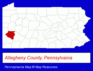
The Pennsylvania counties map at upper right shows Allegheny County, highlighted in red. Use the menu below to display interactive maps of Bethel Park, either in a frame on this page or in full-screen mode.
Use the menu below to display categorized Bethel Park directories.
| Bethel Park Products and Services Directory | ||
|---|---|---|
| Building Materials | Financial Services | Home Improvement |
Selected Bethel Park, Pennsylvania Listings
These representative Bethel Park listings provide some insight into the municipality's cultural environment and economic climate.- Chemicals Wholesale & Manufacturers
- Chemicals Dealers
- Carbon Products
- Graphite
- Insurance Agents & Brokers
- Accountants
- Public Accountants
- Certified Public Accountants
- Industrial Equipment & Supplies Dealers
- Industrial Equipment & Supplies Wholesale & Manufacturers
- Tool & Die Maker Equipment & Supplies
- Visual Arts
- Photography
- Professional Photographers
- Portrait Photographers
- Mortgages
- Personal Loans
- Credit Card Plans & Services
- Credit Card Merchant Services
- Credit Card Equipment & Supplies
Nearby Pennsylvania Cities and Towns *
- Bridgeville (2) - Bridgeville, Pennsylvania information and maps.
- Canonsburg (4) - Canonsburg, Pennsylvania information and maps.
- Coraopolis (3) - Coraopolis, Pennsylvania information and maps.
- Pittsburgh (74) - Pittsburgh, Pennsylvania products & services directory.
- Verona (2) - Verona, Pennsylvania information and maps.
* Parenthesized numbers indicate economic activity levels.
Copyright © 2011-2026 RegionalDirectory.us. All rights reserved.