Brentwood, Tennessee Map and Directory
Regional Directory > States Menu > Tennessee
 According to the United States Census Bureau, Brentwood is a City that is located in Williamson County, Tennessee at 36.03 degrees North and 86.78 degrees West.
The city's time zone is America/Chicago, and the city's primary telephone area code is 615.
The land area of Brentwood is about 41.20 square miles, whereas the water area of the city is about 0.04 square miles.
Williamson County's land area is about 583 square miles, so the city occupies about 7.1 percent of the county's total land area.
According to the United States Census Bureau, Brentwood is a City that is located in Williamson County, Tennessee at 36.03 degrees North and 86.78 degrees West.
The city's time zone is America/Chicago, and the city's primary telephone area code is 615.
The land area of Brentwood is about 41.20 square miles, whereas the water area of the city is about 0.04 square miles.
Williamson County's land area is about 583 square miles, so the city occupies about 7.1 percent of the county's total land area.
The Census Bureau estimates that Brentwood had about 42,783 residents in 2019, which is approximately 1,038 people per square mile of land area.
According to recent American Community Survey data, the median household income in Brentwood was about $168,688 per year.
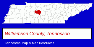
The Tennessee counties map at upper right shows Williamson County, highlighted in red. Use the menu below to display interactive maps of Brentwood, either in a frame on this page or in full-screen mode.
Use the menu below to display categorized Brentwood directories.
| Brentwood Products and Services Directory | ||
|---|---|---|
| Accountants | Architects | Building Contractors |
| Business Services | Chiropractors | Clinics |
| Dentists | Financial Services | Hair Removal |
| Information Technology | Insurance | Physicians |
| Restaurants | Schools | |
Selected Brentwood, Tennessee Listings
These randomly selected Brentwood listings provide some insight into the city's cultural environment and economic climate.- Financing
- Investment Advisory Services
- Airport Transportation
- Auto Transport
- Limousine Services
- Retirement Planning Consultants & Services
- Church & Religious Associations & Organizations
- Optometrists
- Community & Civic Organizations
- Mental Health
- Counseling Services
- Psychologists
- Health Care Professionals
- Mental Health Counselors
- Japanese Restaurants
- Educational Consultants
- Test Preparation & Tutoring Services
- Antiques
- Auctions
- Antique Dealers
- Auctioneers & Auction Houses
- Certified Public Accountants
- Financing
- Financial Management & Consulting
- Skin Care
- Skin Care Cosmetics
- Coffee & Tea Shops
- Architectural Engineers
Nearby Tennessee Cities and Towns *
- Columbia (8) - Columbia, Tennessee demographics and maps.
- Franklin (32) - Franklin, Tennessee solutions directory and maps.
- Hendersonville (10) - Hendersonville, Tennessee demographics and directory.
- Mount Juliet (6) - Mount Juliet, Tennessee demographics and maps.
- Murfreesboro (30) - Murfreesboro, Tennessee solutions directory and maps.
- Nashville (122) - Nashville, Tennessee products & services directory.
- Smyrna (6) - Smyrna, Tennessee demographics and maps.
* Parenthesized numbers indicate economic activity levels.
Copyright © 2011-2026 RegionalDirectory.us. All rights reserved.