Cookeville, Tennessee Map and Directory
Regional Directory > States Menu > Tennessee
 According to the United States Census Bureau, Cookeville is a City that is located in Putnam County, Tennessee at 36.16 degrees North and 85.50 degrees West.
The city's time zone is America/Chicago, and the city's primary telephone area code is 931.
The land area of Cookeville is about 35.34 square miles, whereas the water area of the city is about 0.18 square miles.
Putnam County's land area is about 401 square miles, so the city occupies about 8.8 percent of the county's total land area.
According to the United States Census Bureau, Cookeville is a City that is located in Putnam County, Tennessee at 36.16 degrees North and 85.50 degrees West.
The city's time zone is America/Chicago, and the city's primary telephone area code is 931.
The land area of Cookeville is about 35.34 square miles, whereas the water area of the city is about 0.18 square miles.
Putnam County's land area is about 401 square miles, so the city occupies about 8.8 percent of the county's total land area.
The Census Bureau estimates that Cookeville had about 34,706 residents in 2019, which is approximately 982 people per square mile of land area.
According to recent American Community Survey data, the median household income in Cookeville was about $38,256 per year.
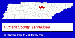
The Tennessee counties map at upper right shows Putnam County, highlighted in red. Use the menu below to display interactive maps of Cookeville, either in a frame on this page or in full-screen mode.
Use the menu below to display categorized Cookeville directories.
| Cookeville Products and Services Directory | ||
|---|---|---|
| Attorneys | Banks | Business Services |
| Dentists | Financial Services | Home Improvement |
| Insurance | Physicians | |
Selected Cookeville, Tennessee Listings
These randomly selected Cookeville listings provide some insight into the city's cultural environment and economic climate.- Towing
- Auto Glass Retail
- Used & Rebuilt Auto Parts Wholesale & Manufacturers
- Auto Glass Replacement & Repair
- Industrial Equipment & Supplies Dealers
- Industrial Equipment & Supplies Wholesale & Manufacturers
- Party Equipment & Supplies Sales & Rental
- Tool Rental & Leasing
- Pest Control Services
- Sporting Goods Dealers
- Camps
- Sporting Goods
- Camping Equipment & Supplies Dealers
- Football Clubs & Instruction
- Auto Insurance
- Health Insurance
- Medical Claims Processing & Assistance
- Landscape Contractors
- Caterers
- Grocery Stores & Supermarkets
- Convenience Stores
- Catering Equipment & Supplies Retail
- Home Furnishings Stores
- Furniture Stores
- Libraries
- Building & Home Construction
- Building Contractors
- Construction Companies
- Caterers
- Wedding Caterers
- Recreation Centers
- Roller Skating Rinks & Instruction
- High Schools
- Christian Schools
- Commercial Printing
- Newspaper Publishers
Nearby Tennessee Cities and Towns *
- Crossville (5) - Crossville, Tennessee demographics and maps.
- Gallatin (3) - Gallatin, Tennessee information and maps.
- Lafayette (2) - Lafayette, Tennessee information and maps.
- Lebanon (6) - Lebanon, Tennessee demographics and maps.
- Mount Juliet (6) - Mount Juliet, Tennessee demographics and maps.
- Murfreesboro (30) - Murfreesboro, Tennessee solutions directory and maps.
- Smyrna (6) - Smyrna, Tennessee demographics and maps.
* Parenthesized numbers indicate economic activity levels.
Copyright © 2011-2026 RegionalDirectory.us. All rights reserved.