Irving, Texas Map and Directory
Regional Directory > States Menu > Texas
 According to the United States Census Bureau, Irving is a City that is located in Dallas County, Texas at 32.81 degrees North and 96.95 degrees West.
The city's time zone is America/Chicago, and the city's primary telephone area code is 972.
The land area of Irving is about 67.02 square miles, whereas the water area of the city is about 1.00 square miles.
Dallas County's land area is about 871 square miles, so the city occupies about 7.7 percent of the county's total land area.
According to the United States Census Bureau, Irving is a City that is located in Dallas County, Texas at 32.81 degrees North and 96.95 degrees West.
The city's time zone is America/Chicago, and the city's primary telephone area code is 972.
The land area of Irving is about 67.02 square miles, whereas the water area of the city is about 1.00 square miles.
Dallas County's land area is about 871 square miles, so the city occupies about 7.7 percent of the county's total land area.
The Census Bureau estimates that Irving had about 239,798 residents in 2019, which is approximately 3,578 people per square mile of land area.
According to recent American Community Survey data, the median household income in Irving was about $64,868 per year.
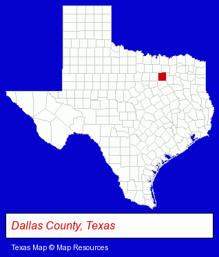
The Texas counties map at upper right shows Dallas County, highlighted in red. Use the menu below to display interactive maps of Irving, either in a frame on this page or in full-screen mode.
Use the menu below to display categorized Irving directories.
| Irving Products and Services Directory | ||
|---|---|---|
| Auto Service | Business Services | Chiropractors |
| Clinics | Dentists | Home Improvement |
| Information Technology | Locksmiths | Metals |
| Movers | Moving and Storage | Orthopedists |
| Physicians | Restaurants | Schools |
| Travel Agents | Visual Arts | |
Selected Irving, Texas Listings
These randomly selected Irving listings provide some insight into the city's cultural environment and economic climate.- Medical Equipment & Supplies Retail
- Health Care Professionals
- Welding Services
- Family & General Practice Physicians & Surgeons
- Internal Medicine Physicians & Surgeons
- Gastroenterology Physicians & Surgeons
- Rehabilitation Services
- Vocational Education
- Electric & Electronic Equipment & Supplies
- Consumer Electronics Stores
- Electric Equipment & Supplies Dealers
- Electric Equipment & Supplies Wholesale & Manufacturers
- Financial Institutions
- Mortgage & Loan Banks
- Libraries
- Auto Locks & Lockout Services
- Auto Alarms & Security Systems
- Locks & Locksmiths Commercial & Industrial
- Metal Buildings Dealers
- Business Consultants & Advisors
- Management Consultants
- Business Management Services
- Building & Home Construction
- Special Trades Contractors
- Painting Contractors
- Painting Contractors Commercial & Industrial
- Retirement Communities & Homes
- Retirement & Life Care Centers
- Retirement Planning Consultants & Services
- Pediatrics Physicians & Surgeons
- Food Equipment & Supplies
Nearby Texas Cities and Towns *
- Arlington (49) - Arlington, Texas products & services directory.
- Bedford (2) - Bedford, Texas information and maps.
- Coppell (3) - Coppell, Texas information and maps.
- Dallas (198) - Dallas, Texas products & services directory.
- Euless (3) - Euless, Texas information and maps.
- Grand Prairie (11) - Grand Prairie, Texas demographics and directory.
- Grapevine (5) - Grapevine, Texas demographics and maps.
* Parenthesized numbers indicate economic activity levels.
Copyright © 2011-2026 RegionalDirectory.us. All rights reserved.