Arlington, Virginia Map and Directory
Regional Directory > States Menu > Virginia
 According to the United States Census Bureau, Arlington is a Census-designated Place that is located in Arlington County, Virginia at 38.89 degrees North and 77.08 degrees West.
The place's time zone is America/New York, and the place's primary telephone area code is 571.
The land area of Arlington is about 25.99 square miles, whereas the water area of the place is about 0.09 square miles.
Arlington County's land area is about 26 square miles, so the place occupies about 100.0 percent of the county's total land area.
According to the United States Census Bureau, Arlington is a Census-designated Place that is located in Arlington County, Virginia at 38.89 degrees North and 77.08 degrees West.
The place's time zone is America/New York, and the place's primary telephone area code is 571.
The land area of Arlington is about 25.99 square miles, whereas the water area of the place is about 0.09 square miles.
Arlington County's land area is about 26 square miles, so the place occupies about 100.0 percent of the county's total land area.
The Census Bureau estimates that Arlington had about 233,464 residents in 2019, which is approximately 8,983 people per square mile of land area.
According to recent American Community Survey data, the median household income in Arlington was about $120,071 per year.
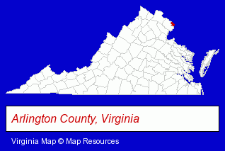
The Virginia counties map at upper right shows Arlington County, highlighted in red. Use the menu below to display interactive maps of Arlington, either in a frame on this page or in full-screen mode.
Use the menu below to display categorized Arlington directories.
| Arlington Products and Services Directory | ||
|---|---|---|
| Architects | Attorneys | Business Services |
| Chiropractors | Clinics | Dentists |
| Hotels | Information Technology | Insurance |
| Market Research | Physicians | Printing and Publishing |
| Restaurants | Schools | Steak Restaurants |
| Thai Restaurants | ||
Selected Arlington, Virginia Listings
These randomly selected Arlington listings provide some insight into the place's cultural environment and economic climate. Dimension Strategic Corporation- Business Consultants & Advisors
- Management Consultants
- Business Management Services
- Marketing Consultants
- Sports & Recreation Facilities
- Health Clubs & Gyms
- Exercise & Fitness Classes & Instruction
- Fitness Consultants
- Personal Trainers
- Moving & Storage
- Real Estate Agencies & Brokerage
- Real Estate Consultants
- Real Estate Buyer Consultants
- Relocation Services
- Caterers
- Banquet Facilities
- Take Out
- Fast Food Restaurants
- Rehabilitation Services
- Orthopedics Physicians & Surgeons
- Sports & Recreation Facilities
- Health Clubs & Gyms
- Sports & Recreation Clubs & Organizations
- Country Clubs
Nearby Virginia Cities and Towns *
- Alexandria (33) - Alexandria, Virginia products & services directory.
- Burke (2) - Burke, Virginia information and maps.
- Fairfax (23) - Fairfax, Virginia solutions directory and maps.
- Falls Church (11) - Falls Church, Virginia demographics and directory.
- Oakton (3) - Oakton, Virginia information and maps.
- Springfield (8) - Springfield, Virginia demographics and maps.
- Vienna (13) - Vienna, Virginia demographics and directory.
Large and Mid-size Cities in Nearby States
- Bethesda, Maryland (15) - Bethesda, MD demographics and directory.
- Silver Spring, Maryland (14) - Silver Spring, MD demographics and directory.
* Parenthesized numbers indicate economic activity levels.
Copyright © 2011-2026 RegionalDirectory.us. All rights reserved.