Port Angeles, Washington Map and Directory
Regional Directory > States Menu > Washington
 According to the United States Census Bureau, Port Angeles is a City that is located in Clallam County, Washington at 48.12 degrees North and 123.43 degrees West.
The city's time zone is America/Los Angeles, and the city's primary telephone area code is 360.
The land area of Port Angeles is about 10.70 square miles, whereas the water area of the city is about 3.82 square miles.
Clallam County's land area is about 1,738 square miles, so the city occupies about 0.6 percent of the county's total land area.
According to the United States Census Bureau, Port Angeles is a City that is located in Clallam County, Washington at 48.12 degrees North and 123.43 degrees West.
The city's time zone is America/Los Angeles, and the city's primary telephone area code is 360.
The land area of Port Angeles is about 10.70 square miles, whereas the water area of the city is about 3.82 square miles.
Clallam County's land area is about 1,738 square miles, so the city occupies about 0.6 percent of the county's total land area.
The Census Bureau estimates that Port Angeles had about 20,229 residents in 2019, which is approximately 1,891 people per square mile of land area.
According to recent American Community Survey data, the median household income in Port Angeles was about $47,256 per year.
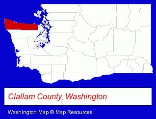
The Washington counties map at upper right shows Clallam County, highlighted in red. Use the menu below to display interactive maps of Port Angeles, either in a frame on this page or in full-screen mode.
Use the menu below to display categorized Port Angeles directories.
| Port Angeles Products and Services Directory | ||
|---|---|---|
| Auto Service | Clinics | Home Improvement |
| Hotels | ||
Selected Port Angeles, Washington Listings
These randomly selected Port Angeles listings provide some insight into the city's cultural environment and economic climate.- Lodging
- Hotels
- Motels
- Hotel & Motel Reservations
- Pest Control Services
- Lawn & Garden Services
- Lawn Services
- Lawn Spraying & Treatment
- Sporting Goods Dealers
- Lodging
- Hotels
- Motels
- Bed & Breakfasts
- Gift Shops
- Department Stores
- Discount Stores
- Marine Professionals & Services
- Boat Builders & Wholesalers
- Lodging
- Hotels
- Hotel & Motel Reservations
- Land Surveyors
Nearby Washington Cities and Towns *
- Friday Harbor (3) - Friday Harbor, Washington information and maps.
- Port Townsend (5) - Port Townsend, Washington demographics and maps.
- Poulsbo (7) - Poulsbo, Washington demographics and maps.
- Sequim (3) - Sequim, Washington information and maps.
* Parenthesized numbers indicate economic activity levels.
Copyright © 2011-2026 RegionalDirectory.us. All rights reserved.