Bayfield, Colorado Map and Directory
Regional Directory > States Menu > Colorado
 According to the United States Census Bureau, Bayfield is a Town that is located in La Plata County, Colorado at 37.23 degrees North and 107.60 degrees West.
The town's time zone is America/Denver, and the town's primary telephone area code is 970.
The land area of Bayfield is about 1.44 square miles, whereas the water area of the town is about 0.00 square miles.
La Plata County's land area is about 1,692 square miles, so the town occupies about 0.1 percent of the county's total land area.
According to the United States Census Bureau, Bayfield is a Town that is located in La Plata County, Colorado at 37.23 degrees North and 107.60 degrees West.
The town's time zone is America/Denver, and the town's primary telephone area code is 970.
The land area of Bayfield is about 1.44 square miles, whereas the water area of the town is about 0.00 square miles.
La Plata County's land area is about 1,692 square miles, so the town occupies about 0.1 percent of the county's total land area.
The Census Bureau estimates that Bayfield had about 2,533 residents in 2014, which is approximately 1,759 people per square mile of land area.
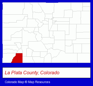
The Colorado counties map at upper right shows La Plata County, highlighted in red. Use the menu below to display interactive maps of Bayfield, either in a frame on this page or in full-screen mode.
Use the menu below to display categorized Bayfield directories.
| Bayfield Directory Page: | Hotels |
|---|
Nearby Colorado Cities and Towns *
- Cortez (1) - Cortez, Colorado information and maps.
- Durango (17) - Durango, Colorado solutions directory and maps.
- Mancos (1) - Mancos, Colorado information and maps.
- Ouray (1) - Ouray, Colorado information and maps.
- Pagosa Springs (1) - Pagosa Springs, Colorado information and maps.
- Silverton (1) - Silverton, Colorado information and maps.
- Telluride (2) - Telluride, Colorado information and maps.
* Parenthesized numbers indicate economic activity levels.
Copyright © 2011-2024 RegionalDirectory.us. All rights reserved.