Hodgenville, Kentucky Map and Directory
Regional Directory > States Menu > Kentucky
 According to the United States Census Bureau, Hodgenville is a City that is located in Larue County, Kentucky at 37.57 degrees North and 85.74 degrees West.
The city's time zone is America/New York, and the city's primary telephone area code is 270.
The land area of Hodgenville is about 2.11 square miles, whereas the water area of the city is about 0.01 square miles.
Larue County's land area is about 262 square miles, so the city occupies about 0.8 percent of the county's total land area.
According to the United States Census Bureau, Hodgenville is a City that is located in Larue County, Kentucky at 37.57 degrees North and 85.74 degrees West.
The city's time zone is America/New York, and the city's primary telephone area code is 270.
The land area of Hodgenville is about 2.11 square miles, whereas the water area of the city is about 0.01 square miles.
Larue County's land area is about 262 square miles, so the city occupies about 0.8 percent of the county's total land area.
The Census Bureau estimates that Hodgenville had about 3,242 residents in 2014, which is approximately 1,536 people per square mile of land area.
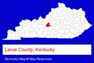
The Kentucky counties map at upper right shows Larue County, highlighted in red. Use the menu below to display interactive maps of Hodgenville, either in a frame on this page or in full-screen mode.
Use the menu below to display categorized Hodgenville directories.
| Hodgenville Directory Page: | Home Improvement |
|---|
Nearby Kentucky Cities and Towns *
- Bowling Green (11) - Bowling Green, Kentucky demographics and directory.
- Elizabethtown (3) - Elizabethtown, Kentucky information and maps.
- Lexington (39) - Lexington, Kentucky products & services directory.
- Louisville (92) - Louisville, Kentucky products & services directory.
- Owensboro (6) - Owensboro, Kentucky demographics and maps.
- Prospect (1) - Prospect, Kentucky information and maps.
- Shelbyville (2) - Shelbyville, Kentucky information and maps.
* Parenthesized numbers indicate economic activity levels.
Copyright © 2011-2024 RegionalDirectory.us. All rights reserved.