Ottawa, Kansas Map and Directory
Regional Directory > States Menu > Kansas
 According to the United States Census Bureau, Ottawa is a City that is located in Franklin County, Kansas at 38.62 degrees North and 95.27 degrees West.
The city's time zone is America/Chicago, and the city's primary telephone area code is 785.
The land area of Ottawa is about 9.75 square miles, whereas the water area of the city is about 0.10 square miles.
Franklin County's land area is about 572 square miles, so the city occupies about 1.7 percent of the county's total land area.
According to the United States Census Bureau, Ottawa is a City that is located in Franklin County, Kansas at 38.62 degrees North and 95.27 degrees West.
The city's time zone is America/Chicago, and the city's primary telephone area code is 785.
The land area of Ottawa is about 9.75 square miles, whereas the water area of the city is about 0.10 square miles.
Franklin County's land area is about 572 square miles, so the city occupies about 1.7 percent of the county's total land area.
The Census Bureau estimates that Ottawa had about 12,254 residents in 2019, which is approximately 1,257 people per square mile of land area.
According to recent American Community Survey data, the median household income in Ottawa was about $46,808 per year.
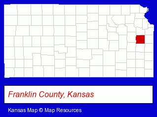
The Kansas counties map at upper right shows Franklin County, highlighted in red. Use the menu below to display interactive maps of Ottawa, either in a frame on this page or in full-screen mode.
Use the menu below to display categorized Ottawa directories.
| Ottawa Directory Page: | Physicians |
|---|
Selected Ottawa, Kansas Listings
These Ottawa listings provide some insight into the city's cultural environment and economic climate.- Optometrists
- Optical Goods Retail
- Tires Retail
- Wheel & Tire Service & Repair
- Truck Tires
- Aircraft Parts & Equipment Retail
- Truck Dealers
- Trucking Companies
- Freight Forwarding
- Dump Trucking
- Home Improvement & Maintenance
- Building Materials & Supplies Dealers
- Concrete & Concrete Products Dealers
- Asphalt & Asphalt Products
- Paving Materials
- Sports Camps
- General Real Estate
- Auctions
- Auctioneers & Auction Houses
- Banks
- Mortgages
- Radio Stations
- Government Contractors
- Radio Stations
- Sporting Goods Dealers
- Sportswear Retail
- Football Clubs & Instruction
- Schools
- Colleges & Universities
- Institutional Libraries
- Nurses
- Health Care Professionals
- Nurse Practitioners
- Printing Services
- Commercial Printing
- Newspaper Publishers
- Libraries
- Public Libraries
Nearby Kansas Cities and Towns *
- Gardner (2) - Gardner, Kansas information and maps.
- Lenexa (17) - Lenexa, Kansas solutions directory and maps.
- Olathe (28) - Olathe, Kansas solutions directory and maps.
- Overland Park (51) - Overland Park, Kansas products & services directory.
- Topeka (38) - Topeka, Kansas products & services directory.
* Parenthesized numbers indicate economic activity levels.
Copyright © 2011-2026 RegionalDirectory.us. All rights reserved.