Rockford, Michigan Map and Directory
Regional Directory > States Menu > Michigan
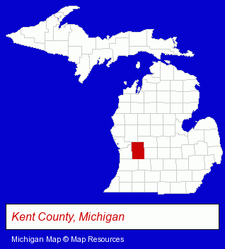 According to the United States Census Bureau, Rockford is a City that is located in Kent County, Michigan at 43.12 degrees North and 85.56 degrees West.
The city's time zone is America/Detroit, and the city's primary telephone area code is 616.
The land area of Rockford is about 3.25 square miles, whereas the water area of the city is about 0.07 square miles.
Kent County's land area is about 847 square miles, so the city occupies about 0.4 percent of the county's total land area.
According to the United States Census Bureau, Rockford is a City that is located in Kent County, Michigan at 43.12 degrees North and 85.56 degrees West.
The city's time zone is America/Detroit, and the city's primary telephone area code is 616.
The land area of Rockford is about 3.25 square miles, whereas the water area of the city is about 0.07 square miles.
Kent County's land area is about 847 square miles, so the city occupies about 0.4 percent of the county's total land area.
The Census Bureau estimates that Rockford had about 6,391 residents in 2019, which is approximately 1,966 people per square mile of land area.
According to recent American Community Survey data, the median household income in Rockford was about $64,920 per year.
The Michigan counties map at upper right shows Kent County, highlighted in red. Use the menu below to display interactive maps of Rockford, either in a frame on this page or in full-screen mode.
Use the menu below to display categorized Rockford directories.
| Rockford Products and Services Directory | |
|---|---|
| Home Improvement | Metals |
Selected Rockford, Michigan Listings
These representative Rockford listings provide some insight into the city's cultural environment and economic climate.- Building & Home Construction
- Builders & Contractors
- Roofing Contractors
- Roofing
- Excavation Contractors
- Construction Machinery & Equipment Dealers
- Concrete Construction Equipment & Supplies
- Alternative Medicine
- Beauty Salons
- Hair Care & Treatment
- Manicures & Pedicures
- Educational Consultants
- Auto Parts Retail
- Building Materials & Supplies Wholesale & Manufacturers
- Plastic & Plastic Products Wholesale & Manufacturers
- Hardware Wholesale & Manufacturers
- Paving Contractors
- Pavement & Parking Area Maintenance & Marking
- Asphalt Paving Contractors
- Driveway Contractors & Construction
- Sealers
- Auto Service & Repair
- Towing
- Business Services
- Business Consultants & Advisors
- Advertising
- Advertising Agencies & Consultants
- Advertising & Design Agencies
- Charitable & Nonprofit Organizations
- Ambulance Services
- Emergency Ambulance Services
- Elderly & Disabled Transportation Services
- Interior Decorators & Designers
- Orthodontics Dentists
- Laboratories
- Testing Laboratories
- Environmental Testing Laboratories
- Radon Testing & Mitigation
Nearby Michigan Cities and Towns *
- Ada (1) - Ada, Michigan information and maps.
- Comstock Park (1) - Comstock Park, Michigan information and maps.
- Grand Rapids (81) - Grand Rapids, Michigan products & services directory.
- Grandville (4) - Grandville, Michigan information and maps.
- Sparta (1) - Sparta, Michigan information and maps.
- Wyoming (5) - Wyoming, Michigan demographics and maps.
* Parenthesized numbers indicate economic activity levels.
Copyright © 2011-2026 RegionalDirectory.us. All rights reserved.