Maryland Heights, Missouri Map and Directory
Regional Directory > States Menu > Missouri
 According to the United States Census Bureau, Maryland Heights is a City that is located in St. Louis County, Missouri at 38.71 degrees North and 90.43 degrees West.
The city's time zone is America/Chicago, and the city's primary telephone area code is 314.
The land area of Maryland Heights is about 21.89 square miles, whereas the water area of the city is about 1.52 square miles.
According to the United States Census Bureau, Maryland Heights is a City that is located in St. Louis County, Missouri at 38.71 degrees North and 90.43 degrees West.
The city's time zone is America/Chicago, and the city's primary telephone area code is 314.
The land area of Maryland Heights is about 21.89 square miles, whereas the water area of the city is about 1.52 square miles.
The Census Bureau estimates that Maryland Heights had about 26,956 residents in 2019, which is approximately 1,231 people per square mile of land area.
According to recent American Community Survey data, the median household income in Maryland Heights was about $66,686 per year.
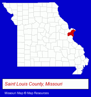
The Missouri counties map at upper right shows St. Louis County, highlighted in red. Use the menu below to display interactive maps of Maryland Heights, either in a frame on this page or in full-screen mode.
Use the menu below to display categorized Maryland Heights directories.
| Maryland Heights Products and Services Directory | ||
|---|---|---|
| Home Improvement | Insurance | Metals |
| Schools | ||
Selected Maryland Heights, Missouri Listings
These randomly selected Maryland Heights listings in 63043 provide a window into the city's cultural environment and economic climate. A1 Limousine & Car Service- Airport Transportation
- Transportation Services
- Industrial Equipment & Supplies Wholesale & Manufacturers
- Machine Shops
- Machine Tools Wholesale & Manufacturing
- Machine Tool Dealers
- Cutting Tools Wholesale & Manufacturers
- Dentists
- Medical Equipment & Supplies Retail
- Hospital Equipment & Supplies Retail
- Medical Equipment & Supplies Wholesale & Manufacturers
- Surgical Instruments Wholesale & Manufacturers
- Packaging & Shipping Materials Retail
- Industrial Equipment & Supplies Dealers
- Industrial Equipment & Supplies Wholesale & Manufacturers
- Medical Equipment & Supplies Retail
- Medical Equipment & Supplies Wholesale & Manufacturers
- Engineers
- Professional Engineers
- Engineering Services
- Florists
- Cutting Tools Wholesale & Manufacturers
- Elementary & Secondary Education
- Elementary Schools
- Charitable & Nonprofit Organizations
- Government Contractors
- Plumbing Contractors
- Government Contractors
- Movers
- Office Furniture & Equipment Wholesale & Manufacturers
- Restaurants
- Pizza Restaurants
- Machine Shops
- Plastic & Plastic Products Wholesale & Manufacturers
- Tool & Die Makers
- Die Cutting Equipment & Supplies
Nearby Missouri Cities and Towns *
- Ballwin (17) - Ballwin, Missouri solutions directory and maps.
- Bridgeton (5) - Bridgeton, Missouri demographics and maps.
- Chesterfield (29) - Chesterfield, Missouri solutions directory and maps.
- Clayton (2) - Clayton, Missouri information and maps.
- Fenton (15) - Fenton, Missouri demographics and directory.
- Florissant (2) - Florissant, Missouri information and maps.
- Saint Charles (22) - Saint Charles, Missouri solutions directory and maps.
* Parenthesized numbers indicate economic activity levels.
Copyright © 2011-2026 RegionalDirectory.us. All rights reserved.