Indian Trail, North Carolina Map and Directory
Regional Directory > States Menu > North Carolina
 According to the United States Census Bureau, Indian Trail is a Town that is located in Union County, North Carolina at 35.08 degrees North and 80.67 degrees West.
The town's time zone is America/New York, and the town's primary telephone area code is 704.
The land area of Indian Trail is about 21.77 square miles, whereas the water area of the town is about 0.17 square miles.
Union County's land area is about 632 square miles, so the town occupies about 3.4 percent of the county's total land area.
According to the United States Census Bureau, Indian Trail is a Town that is located in Union County, North Carolina at 35.08 degrees North and 80.67 degrees West.
The town's time zone is America/New York, and the town's primary telephone area code is 704.
The land area of Indian Trail is about 21.77 square miles, whereas the water area of the town is about 0.17 square miles.
Union County's land area is about 632 square miles, so the town occupies about 3.4 percent of the county's total land area.
The Census Bureau estimates that Indian Trail had about 40,252 residents in 2019, which is approximately 1,849 people per square mile of land area.
According to recent American Community Survey data, the median household income in Indian Trail was about $83,905 per year.
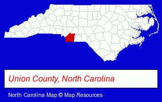
The North Carolina counties map at upper right shows Union County, highlighted in red. Use the menu below to display interactive maps of Indian Trail, either in a frame on this page or in full-screen mode.
Use the menu below to display categorized Indian Trail directories.
| Indian Trail Products and Services Directory | |
|---|---|
| Auctions | Home Improvement |
Selected Indian Trail, North Carolina Listings
These representative Indian Trail listings provide some insight into the town's cultural environment and economic climate.- Vacuum Cleaner Dealers
- Vacuum Cleaning Systems
- Vacuum Cleaner Parts & Supplies Dealers
- Vacuum Cleaner Service & Repair Commercial & Industrial
- Vacuum Cleaner Dealers Commercial & Industrial
- Industrial Equipment & Supplies Dealers
- Resale, Second Hand & Used Merchandise Stores
- Machine Tool Dealers
- Used & Rebuilt Industrial Equipment Dealers
- Auctioneers & Auction Houses
- Public Golf Courses
- Private Golf Courses
- Auto Service & Repair
- Auto Customizing, Conversion & Restoration
- Auto Cleaning & Detailing
- Auto Washing & Polishing
- Government Contractors
- Floors & Flooring Installation
- Floor Resurfacing Materials
- Veterinarians
- Animal Hospitals
- Landscape Contractors
- Landscape Services
- Landscape Designers & Consultants
- Dentists
- Cosmetic Dentists
- Pediatrics Dentists
- Housecleaning
- Maids & Butlers
- Maid & Butler Registries
- Web Site Design
- Web Site Developers
- Internet Marketing Services
- Construction Companies
- Construction Consulting & Management Services
- Window Glass Coating & Tinting
- Energy Conservation Engineers
Nearby North Carolina Cities and Towns *
- Charlotte (171) - Charlotte, North Carolina products & services directory.
- Concord (18) - Concord, North Carolina solutions directory and maps.
- Cornelius (10) - Cornelius, North Carolina demographics and directory.
- Huntersville (11) - Huntersville, North Carolina demographics and directory.
- Matthews (12) - Matthews, North Carolina demographics and directory.
- Monroe (9) - Monroe, North Carolina demographics and directory.
- Pineville (4) - Pineville, North Carolina information and maps.
Large and Mid-size Cities in Nearby States
- Rock Hill, South Carolina (7) - Rock Hill, SC demographics and maps.
* Parenthesized numbers indicate economic activity levels.
Copyright © 2011-2026 RegionalDirectory.us. All rights reserved.