Minot, North Dakota Map and Directory
Regional Directory > States Menu > North Dakota
 According to the United States Census Bureau, Minot is a City that is located in Ward County, North Dakota at 48.23 degrees North and 101.30 degrees West.
The city's time zone is America/Chicago, and the city's primary telephone area code is 701.
The land area of Minot is about 26.88 square miles, whereas the water area of the city is about 0.04 square miles.
Ward County's land area is about 2,013 square miles, so the city occupies about 1.3 percent of the county's total land area.
According to the United States Census Bureau, Minot is a City that is located in Ward County, North Dakota at 48.23 degrees North and 101.30 degrees West.
The city's time zone is America/Chicago, and the city's primary telephone area code is 701.
The land area of Minot is about 26.88 square miles, whereas the water area of the city is about 0.04 square miles.
Ward County's land area is about 2,013 square miles, so the city occupies about 1.3 percent of the county's total land area.
The Census Bureau estimates that Minot had about 47,382 residents in 2019, which is approximately 1,763 people per square mile of land area.
According to recent American Community Survey data, the median household income in Minot was about $66,194 per year.
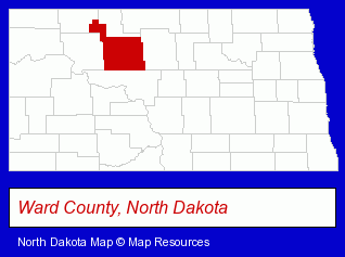
The North Dakota counties map at upper right shows Ward County, highlighted in red. Use the menu below to display interactive maps of Minot, either in a frame on this page or in full-screen mode.
Use the menu below to display categorized Minot directories.
| Minot Products and Services Directory | ||
|---|---|---|
| Accountants | Attorneys | Banks |
| Credit Unions | Dentists | Financial Services |
| Museums | Physicians | Radio Stations |
Selected Minot, North Dakota Listings
These randomly selected Minot listings provide some insight into the city's cultural environment and economic climate.- Consulting Engineers
- Land Surveyors
- Florists
- Computer & Equipment Dealers
- Computers & Equipment Repair & Maintenance
- Consumer Electronics Stores
- Radio Sales & Service
- Televisions Retail
- Utilities
- Electric Companies
- Bakeries
- Property Management
- Shopping Centers & Malls
- Cultural Attractions, Events & Facilities
- Tourist Information & Attractions
- Museums
- Advertising Specialties Wholesale & Manufacturers
- Alternative Medicine
- Chiropractors
- Alternative Medicine Practitioners
- Recreation Centers
- Bowling Alleys
- Garage Doors & Openers
- Door & Door Frame Dealers
- Garage Door Repair
- Home Improvement & Maintenance
- Builders & Contractors
- Building Contractors
- Home Builders & Developers
- Siding Contractors
- Homes & Residential Real Estate
- General Real Estate
- Real Estate Commercial & Industrial
- Real Estate Investments
- Screen Printing
- Advertising Specialties Wholesale & Manufacturers
Nearby North Dakota Cities and Towns *
- Bismarck (31) - Bismarck, North Dakota solutions directory and maps.
- Devils Lake (2) - Devils Lake, North Dakota information and maps.
- Dickinson (2) - Dickinson, North Dakota information and maps.
- Fargo (36) - Fargo, North Dakota products & services directory.
- Grand Forks (13) - Grand Forks, North Dakota demographics and directory.
- Williston (1) - Williston, North Dakota information and maps.
* Parenthesized numbers indicate economic activity levels.
Copyright © 2011-2026 RegionalDirectory.us. All rights reserved.