Pendleton, Oregon Map and Directory
Regional Directory > States Menu > Oregon
 According to the United States Census Bureau, Pendleton is a City that is located in Umatilla County, Oregon at 45.67 degrees North and 118.79 degrees West.
The city's time zone is America/Los Angeles, and the city's primary telephone area code is 541.
The land area of Pendleton is about 10.78 square miles, whereas the water area of the city is about 0.00 square miles.
Umatilla County's land area is about 3,216 square miles, so the city occupies about 0.3 percent of the county's total land area.
According to the United States Census Bureau, Pendleton is a City that is located in Umatilla County, Oregon at 45.67 degrees North and 118.79 degrees West.
The city's time zone is America/Los Angeles, and the city's primary telephone area code is 541.
The land area of Pendleton is about 10.78 square miles, whereas the water area of the city is about 0.00 square miles.
Umatilla County's land area is about 3,216 square miles, so the city occupies about 0.3 percent of the county's total land area.
The Census Bureau estimates that Pendleton had about 16,789 residents in 2019, which is approximately 1,557 people per square mile of land area.
According to recent American Community Survey data, the median household income in Pendleton was about $51,315 per year.
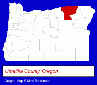
The Oregon counties map at upper right shows Umatilla County, highlighted in red. Use the menu below to display interactive maps of Pendleton, either in a frame on this page or in full-screen mode.
Use the menu below to display categorized Pendleton directories.
| Pendleton Products and Services Directory | |
|---|---|
| Attorneys | Insurance |
Selected Pendleton, Oregon Listings
These representative Pendleton listings provide some insight into the city's cultural environment and economic climate.- Camps
- Sports Camps
- Sign Dealers
- Signs Wholesale & Manufacturers
- Commercial Signs
- Auto Service & Repair
- Auto Body Repair & Painting
- Movers
- Household Goods & Furniture Storage
- Self Service Moving & Storage
- Moving Labor Services
- Hotels
- Hotel & Motel Reservations
- Animal Shelters
- Humane Societies
- Hearing Aids & Assistive Devices Retail
- Audiologists
- Outdoor Sports & Recreation
- RV & Camper Dealers
- ATV Dealers
Nearby Oregon Cities and Towns *
- Bend (66) - Bend, Oregon products & services directory.
- Gresham (8) - Gresham, Oregon demographics and maps.
- Hood River (10) - Hood River, Oregon demographics and directory.
- Joseph (1) - Joseph, Oregon information and maps.
- Oregon City (10) - Oregon City, Oregon demographics and directory.
- Portland (200) - Portland, Oregon products & services directory.
- Redmond (7) - Redmond, Oregon demographics and maps.
Large and Mid-size Cities in Nearby States
- Walla Walla, Washington (8) - Walla Walla, WA demographics and maps.
* Parenthesized numbers indicate economic activity levels.
Copyright © 2011-2026 RegionalDirectory.us. All rights reserved.