Rapid City, South Dakota Map and Directory
Regional Directory > States Menu > South Dakota
 According to the United States Census Bureau, Rapid City is a City that is located in Pennington County, South Dakota at 44.08 degrees North and 103.23 degrees West.
The city's time zone is America/Denver, and the city's primary telephone area code is 605.
The land area of Rapid City is about 54.75 square miles, whereas the water area of the city is about 0.08 square miles.
Pennington County's land area is about 2,777 square miles, so the city occupies about 2.0 percent of the county's total land area.
According to the United States Census Bureau, Rapid City is a City that is located in Pennington County, South Dakota at 44.08 degrees North and 103.23 degrees West.
The city's time zone is America/Denver, and the city's primary telephone area code is 605.
The land area of Rapid City is about 54.75 square miles, whereas the water area of the city is about 0.08 square miles.
Pennington County's land area is about 2,777 square miles, so the city occupies about 2.0 percent of the county's total land area.
The Census Bureau estimates that Rapid City had about 77,503 residents in 2019, which is approximately 1,416 people per square mile of land area.
According to recent American Community Survey data, the median household income in Rapid City was about $52,351 per year.
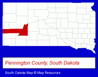
The South Dakota counties map at upper right shows Pennington County, highlighted in red. Use the menu below to display interactive maps of Rapid City, either in a frame on this page or in full-screen mode.
Use the menu below to display categorized Rapid City directories.
| Rapid City Products and Services Directory | ||
|---|---|---|
| Attorneys | Auto Rental | Auto Service |
| Building Materials | Clinics | Dentists |
| Financial Services | Golf Courses | Home Improvement |
| Hotels | Information Technology | Physicians |
| Printing and Publishing | Radio Stations | Schools |
Selected Rapid City, South Dakota Listings
These randomly selected Rapid City listings provide some insight into the city's cultural environment and economic climate.- Sporting Goods Dealers
- Bicycle Dealers
- Bicycle Repair & Maintenance
- Bicycle Rental
- Sporting Goods Rental
- Auctions
- Auctioneers & Auction Houses
- Auto Auctions
- Alternative Medicine
- Chiropractors
- Alternative Medicine Practitioners
- Auto Leasing
- Trailer Rental & Leasing
- Horse & Livestock Trailer Dealers
- Horse Trailer Rental
- Tires Retail
- Wheel & Tire Service & Repair
- Exercise & Fitness Classes & Instruction
- Gymnastics Instruction
- Building & Home Construction
- Industrial Equipment & Supplies Dealers
- Electric & Electronic Equipment & Supplies
- Electric Contractors
- Generator Dealers
- Building Materials & Supplies Wholesale & Manufacturers
- HVAC Equipment & Supplies Dealers
- Plumbing & Heating Supplies Retail
- Heating Equipment Parts & Supplies Dealers
- Optometrists
- Optical Goods Retail
- Industrial Equipment & Supplies Dealers
- Electronic Equipment & Supplies Wholesale & Manufacturers
- Business Consultants & Advisors
- Advertising Agencies & Consultants
Nearby South Dakota Cities and Towns *
- Hill City (1) - Hill City, South Dakota information and maps.
- Sioux Falls (38) - Sioux Falls, South Dakota products & services directory.
* Parenthesized numbers indicate economic activity levels.
Copyright © 2011-2026 RegionalDirectory.us. All rights reserved.