Clarksville, Tennessee Map and Directory
Regional Directory > States Menu > Tennessee
 According to the United States Census Bureau, Clarksville is a City that is located in Montgomery County, Tennessee at 36.53 degrees North and 87.36 degrees West.
The city's time zone is America/Chicago, and the city's primary telephone area code is 931.
The land area of Clarksville is about 98.27 square miles, whereas the water area of the city is about 0.68 square miles.
Montgomery County's land area is about 539 square miles, so the city occupies about 18.2 percent of the county's total land area.
According to the United States Census Bureau, Clarksville is a City that is located in Montgomery County, Tennessee at 36.53 degrees North and 87.36 degrees West.
The city's time zone is America/Chicago, and the city's primary telephone area code is 931.
The land area of Clarksville is about 98.27 square miles, whereas the water area of the city is about 0.68 square miles.
Montgomery County's land area is about 539 square miles, so the city occupies about 18.2 percent of the county's total land area.
The Census Bureau estimates that Clarksville had about 158,146 residents in 2019, which is approximately 1,609 people per square mile of land area.
According to recent American Community Survey data, the median household income in Clarksville was about $53,604 per year.
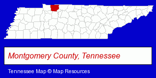
The Tennessee counties map at upper right shows Montgomery County, highlighted in red. Use the menu below to display interactive maps of Clarksville, either in a frame on this page or in full-screen mode.
Use the menu below to display categorized Clarksville directories.
| Clarksville Products and Services Directory | ||
|---|---|---|
| Air Conditioning | Attorneys | Building Contractors |
| Clinics | Construction Companies | Cremation Services |
| Dentists | Florists | Heating Contractors |
| Home Improvement | Insurance | Movers |
| Physicians | Restaurants | Schools |
Selected Clarksville, Tennessee Listings
These randomly selected Clarksville listings provide some insight into the city's cultural environment and economic climate.- Government Contractors
- Maxillofacial Physicians & Surgeons
- Periodontics Dentists
- Veterinarians
- Animal Hospitals
- Churches
- Pentecostal Churches
- Pediatrics Dentists
- Auto Racing
- Cosmetic & Reconstructive Surgeons
- General Practice
- Maxillofacial Physicians & Surgeons
- Civil Engineers
- Geotechnical Engineers
- Property Management
- Wireless Communications
- Shopping Centers & Malls
- Non-Cellular Mobile Phone Service
- Pest Control Services
- Animal Shelters
- Humane Societies
- Pedodontics Dentists
- Gift Baskets & Packs Retail
- Fruit Baskets
- Household Goods & Furniture Storage
- Investment Securities
- Stock & Bond Brokers
- Animal Shelters
- Humane Societies
- Bakeries
- Court Reporting
- Court & Convention Reporters
- Court Reporting Services
- Recreation Centers
- Bowling Alleys
- Pet Food & Supplies Retail
- Pet Shops
- Pet Sitting & Day Care
- Pet Grooming
- Radio Stations
Nearby Tennessee Cities and Towns *
- Brentwood (23) - Brentwood, Tennessee solutions directory and maps.
- Dickson (2) - Dickson, Tennessee information and maps.
- Franklin (32) - Franklin, Tennessee solutions directory and maps.
- Goodlettsville (2) - Goodlettsville, Tennessee information and maps.
- Hendersonville (10) - Hendersonville, Tennessee demographics and directory.
- Nashville (122) - Nashville, Tennessee products & services directory.
- Springfield (2) - Springfield, Tennessee information and maps.
* Parenthesized numbers indicate economic activity levels.
Copyright © 2011-2026 RegionalDirectory.us. All rights reserved.