Arlington, Washington Map and Directory
Regional Directory > States Menu > Washington
 According to the United States Census Bureau, Arlington is a City that is located in Snohomish County, Washington at 48.20 degrees North and 122.13 degrees West.
The city's time zone is America/Los Angeles, and the city's primary telephone area code is 360.
The land area of Arlington is about 9.73 square miles, whereas the water area of the city is about 0.01 square miles.
Snohomish County's land area is about 2,087 square miles, so the city occupies about 0.5 percent of the county's total land area.
According to the United States Census Bureau, Arlington is a City that is located in Snohomish County, Washington at 48.20 degrees North and 122.13 degrees West.
The city's time zone is America/Los Angeles, and the city's primary telephone area code is 360.
The land area of Arlington is about 9.73 square miles, whereas the water area of the city is about 0.01 square miles.
Snohomish County's land area is about 2,087 square miles, so the city occupies about 0.5 percent of the county's total land area.
The Census Bureau estimates that Arlington had about 20,523 residents in 2019, which is approximately 2,109 people per square mile of land area.
According to recent American Community Survey data, the median household income in Arlington was about $82,626 per year.
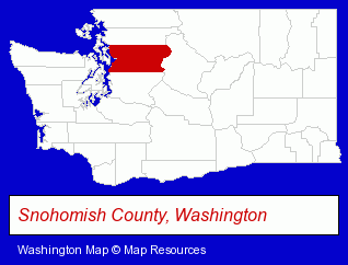
The Washington counties map at upper right shows Snohomish County, highlighted in red. Use the menu below to display interactive maps of Arlington, either in a frame on this page or in full-screen mode.
Use the menu below to display categorized Arlington directories.
| Arlington Products and Services Directory | ||
|---|---|---|
| Building Materials | Home Improvement | Metals |
Selected Arlington, Washington Listings
These representative Arlington listings provide some insight into the city's cultural environment and economic climate.- Restaurants
- American Restaurants
- Steak & Seafood Restaurants
- Fine Dining Restaurants
- Aircraft Parts & Equipment Retail
- Aircraft Painting, Service & Repair
- Aircraft Modification & Overhaul
- Avionics Sales & Service
- Aircraft Radio Equipment
- Physicians & Surgeons
- Alternative Medicine
- Chiropractors
- Alternative Medicine Practitioners
- Sports Medicine Physicians & Surgeons
- Welding Services
- Aircraft Parts & Equipment Wholesale & Manufacturers
- Aircraft Dealers & Distributors
- Aircraft Manufacturers
- Industrial Equipment Rebuilding, Service & Repair
- Auto Machine Shop Services
- Auto Engine Service & Repair
- Balancing Service & Equipment Industrial
- Pet Care Services
- Animal Shelters
- Pet Related Services
- Humane Societies
- Concrete & Concrete Products Dealers
- Ready-Mixed Concrete Dealers
- Decorative & Specialty Concrete
- Aircraft Parts & Equipment Retail
- Aircraft Parts & Equipment Wholesale & Manufacturers
- Aircraft Manufacturers
- Musical Instruments Retail
- Musical Instruments Wholesale & Manufacturers
Nearby Washington Cities and Towns *
- Edmonds (10) - Edmonds, Washington demographics and directory.
- Everett (16) - Everett, Washington demographics and directory.
- Lynnwood (10) - Lynnwood, Washington demographics and directory.
- Marysville (2) - Marysville, Washington information and maps.
- Mount Vernon (3) - Mount Vernon, Washington information and maps.
- Mukilteo (2) - Mukilteo, Washington information and maps.
- Snohomish (3) - Snohomish, Washington information and maps.
* Parenthesized numbers indicate economic activity levels.
Copyright © 2011-2026 RegionalDirectory.us. All rights reserved.