Wheat Ridge, Colorado Map and Directory
Regional Directory > States Menu > Colorado
 According to the United States Census Bureau, Wheat Ridge is a City that is located in Jefferson County, Colorado at 39.77 degrees North and 105.08 degrees West.
The city's time zone is America/Denver, and the city's primary telephone area code is 303.
The land area of Wheat Ridge is about 9.37 square miles, whereas the water area of the city is about 0.25 square miles.
Jefferson County's land area is about 764 square miles, so the city occupies about 1.2 percent of the county's total land area.
According to the United States Census Bureau, Wheat Ridge is a City that is located in Jefferson County, Colorado at 39.77 degrees North and 105.08 degrees West.
The city's time zone is America/Denver, and the city's primary telephone area code is 303.
The land area of Wheat Ridge is about 9.37 square miles, whereas the water area of the city is about 0.25 square miles.
Jefferson County's land area is about 764 square miles, so the city occupies about 1.2 percent of the county's total land area.
The Census Bureau estimates that Wheat Ridge had about 31,324 residents in 2019, which is approximately 3,343 people per square mile of land area.
According to recent American Community Survey data, the median household income in Wheat Ridge was about $57,659 per year.
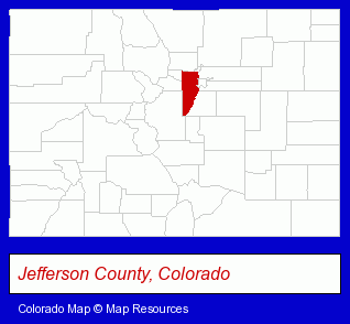
The Colorado counties map at upper right shows Jefferson County, highlighted in red. Use the menu below to display interactive maps of Wheat Ridge, either in a frame on this page or in full-screen mode.
Use the menu below to display categorized Wheat Ridge directories.
| Wheat Ridge Products and Services Directory | ||
|---|---|---|
| Auto Service | Home Improvement | Physicians |
Selected Wheat Ridge, Colorado Listings
These representative Wheat Ridge listings provide some insight into the city's cultural environment and economic climate.- Building & Home Construction
- Special Trades Contractors
- Electric Contractors
- Electric Contractors Residential
- Alternative Medicine
- Chiropractors
- Alternative Medicine Practitioners
- Industrial Equipment & Supplies Dealers
- Industrial Equipment & Supplies Wholesale & Manufacturers
- Mail Services & Package Shipping
- Product Packaging, Labeling & Shipping
- Mailing Equipment & Supplies
- Building & Home Construction
- Builders & Contractors
- Foundation Contractors
- Auto Inspection
- Auto Emissions Testing & Repair
- Design
- Interior Decorators & Designers Commercial & Industrial
- Interior Plants Design & Maintenance
- Interior Landscaping
- Accountants
- Public Accountants
- Certified Public Accountants
- Bicycle Dealers
- Exercise & Fitness Equipment Dealers
- Bicycle Repair & Maintenance
- Bicycle Rental
- Exercise & Fitness Equipment Service & Repair
Nearby Colorado Cities and Towns *
- Arvada (13) - Arvada, Colorado demographics and directory.
- Commerce City (6) - Commerce City, Colorado demographics and maps.
- Denver (144) - Denver, Colorado products & services directory.
- Englewood (33) - Englewood, Colorado products & services directory.
- Golden (7) - Golden, Colorado demographics and maps.
- Lakewood (1) - Lakewood, Colorado information and maps.
- Westminster (2) - Westminster, Colorado information and maps.
Large and Mid-size Cities in Nearby States
- Cheyenne, Wyoming (11) - Cheyenne, WY demographics and maps.
* Parenthesized numbers indicate economic activity levels.
Copyright © 2011-2026 RegionalDirectory.us. All rights reserved.