Auburn, Massachusetts Map and Directory
Regional Directory > States Menu > Massachusetts
 According to the United States Census Bureau, Auburn is a Town that is located in Worcester County, Massachusetts at 42.20 degrees North and 71.85 degrees West.
The town's time zone is America/New York, and the town's primary telephone area code is 774.
The land area of Auburn is about 15.48 square miles, whereas the water area of the town is about 0.93 square miles.
Worcester County's land area is about 1,511 square miles, so the town occupies about 1.0 percent of the county's total land area.
According to the United States Census Bureau, Auburn is a Town that is located in Worcester County, Massachusetts at 42.20 degrees North and 71.85 degrees West.
The town's time zone is America/New York, and the town's primary telephone area code is 774.
The land area of Auburn is about 15.48 square miles, whereas the water area of the town is about 0.93 square miles.
Worcester County's land area is about 1,511 square miles, so the town occupies about 1.0 percent of the county's total land area.
The Census Bureau estimates that Auburn had about 16,684 residents in 2019, which is approximately 1,078 people per square mile of land area.
According to recent American Community Survey data, the median household income in Auburn was about $84,740 per year.
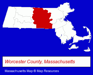
The Massachusetts counties map at upper right shows Worcester County, highlighted in red. Use the menu below to display interactive maps of Auburn, either in a frame on this page or in full-screen mode.
Use the menu below to display categorized Auburn directories.
| Auburn Products and Services Directory | |
|---|---|
| Home Improvement | Metals |
Selected Auburn, Massachusetts Listings
These representative Auburn listings provide some insight into the town's cultural environment and economic climate.- Pet Care Services
- Pet Grooming
- Fruits & Vegetables Wholesale
- Food Processing & Manufacturers
- Nut Wholesalers & Processors
- Dentists
- Cosmetic Dentists
- Pedodontics Dentists
- Emergency Services Dentists
- General Anesthesia & Sedation Dentists
- Optometrists
- Contact Lenses
- Roofing Contractors
- Gutters & Downspouts Dealers
- Physicians & Surgeons
- Pediatrics Physicians & Surgeons
- General Practice
- Insurance
- Insurance Consultants & Advisors
- Auto Rental
- Motorcycle, Motor Scooter & Minibike Dealers
- Motorcycle, Motor Scooter & ATV Service & Repair
- Motorcycle, Motor Scooter & Minibike Parts & Accessories
- Motorcycle & Motor Scooter Rental
- Construction Companies
- Construction Consulting & Management Services
- Industrial Equipment & Supplies Wholesale & Manufacturers
- Tool & Die Makers
- Machine Tools Wholesale & Manufacturing
- Auto Parts Retail
- Camps
- RV & Camper Dealers
- Auto Alignment, Frame & Axle Service & Repair
- Elevator Installation, Testing & Repair
- Elevator Contractors
- Elevator Dealers
Nearby Massachusetts Cities and Towns *
- Northborough (1) - Northborough, Massachusetts information and maps.
- Paxton (1) - Paxton, Massachusetts information and maps.
- Shrewsbury (1) - Shrewsbury, Massachusetts information and maps.
- Spencer (1) - Spencer, Massachusetts information and maps.
- Sterling (2) - Sterling, Massachusetts information and maps.
- Westborough (7) - Westborough, Massachusetts demographics and maps.
- Worcester (34) - Worcester, Massachusetts products & services directory.
* Parenthesized numbers indicate economic activity levels.
Copyright © 2011-2026 RegionalDirectory.us. All rights reserved.