Milton, Massachusetts Map and Directory
Regional Directory > States Menu > Massachusetts
 According to the United States Census Bureau, Milton is a Town that is located in Norfolk County, Massachusetts at 42.24 degrees North and 71.08 degrees West.
The town's time zone is America/New York, and the town's primary telephone area code is 857.
The land area of Milton is about 13.01 square miles, whereas the water area of the town is about 0.29 square miles.
Norfolk County's land area is about 396 square miles, so the town occupies about 3.3 percent of the county's total land area.
According to the United States Census Bureau, Milton is a Town that is located in Norfolk County, Massachusetts at 42.24 degrees North and 71.08 degrees West.
The town's time zone is America/New York, and the town's primary telephone area code is 857.
The land area of Milton is about 13.01 square miles, whereas the water area of the town is about 0.29 square miles.
Norfolk County's land area is about 396 square miles, so the town occupies about 3.3 percent of the county's total land area.
The Census Bureau estimates that Milton had about 27,572 residents in 2019, which is approximately 2,119 people per square mile of land area.
According to recent American Community Survey data, the median household income in Milton was about $133,718 per year.
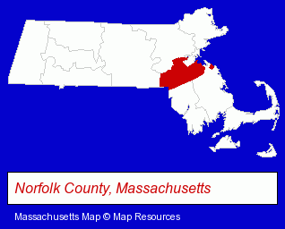
The Massachusetts counties map at upper right shows Norfolk County, highlighted in red. Use the menu below to display interactive maps of Milton, either in a frame on this page or in full-screen mode.
Use the menu below to display categorized Milton directories.
| Milton Directory Page: | Dentists |
|---|
Selected Milton, Massachusetts Listings
These Milton listings provide some insight into the town's cultural environment and economic climate.- Restaurants
- Caterers
- Physicians & Surgeons
- General Practice
- Charitable & Nonprofit Organizations
- Cultural Attractions, Events & Facilities
- Tourist Information & Attractions
- Museums
- Accountants
- Public Accountants
- Certified Public Accountants
- Health Clubs & Gyms
- Restaurants
- Business Services
- Business Consultants & Advisors
- Management Consultants
- Business Management Services
- Computers & Equipment Wholesale & Manufacturers
- Building & Home Construction
- Architects
- Architectural Services
- Auctions
- Auctioneers & Auction Houses
- Insurance
Nearby Massachusetts Cities and Towns *
- Boston (96) - Boston, Massachusetts products & services directory.
- Brookline (11) - Brookline, Massachusetts demographics and directory.
- Dedham (8) - Dedham, Massachusetts demographics and maps.
- Needham (9) - Needham, Massachusetts demographics and directory.
- Norwood (10) - Norwood, Massachusetts demographics and directory.
- Quincy (17) - Quincy, Massachusetts solutions directory and maps.
- Stoughton (8) - Stoughton, Massachusetts demographics and maps.
* Parenthesized numbers indicate economic activity levels.
Copyright © 2011-2026 RegionalDirectory.us. All rights reserved.