Red Lodge, Montana Map and Directory
Regional Directory > States Menu > Montana
 According to the United States Census Bureau, Red Lodge is a City that is located in Carbon County, Montana at 45.19 degrees North and 109.25 degrees West.
The city's time zone is America/Denver, and the city's primary telephone area code is 406.
The land area of Red Lodge is about 2.71 square miles, whereas the water area of the city is about 0.00 square miles.
Carbon County's land area is about 2,049 square miles, so the city occupies about 0.1 percent of the county's total land area.
According to the United States Census Bureau, Red Lodge is a City that is located in Carbon County, Montana at 45.19 degrees North and 109.25 degrees West.
The city's time zone is America/Denver, and the city's primary telephone area code is 406.
The land area of Red Lodge is about 2.71 square miles, whereas the water area of the city is about 0.00 square miles.
Carbon County's land area is about 2,049 square miles, so the city occupies about 0.1 percent of the county's total land area.
The Census Bureau estimates that Red Lodge had about 2,215 residents in 2014, which is approximately 817 people per square mile of land area.
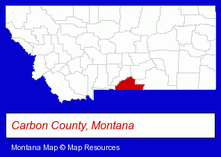
The Montana counties map at upper right shows Carbon County, highlighted in red. Use the menu below to display interactive maps of Red Lodge, either in a frame on this page or in full-screen mode.
Use the menu below to display categorized Red Lodge directories.
| Red Lodge Products and Services Directory | |
|---|---|
| Hotels | Vacation Home Rental |
Selected Red Lodge, Montana Listings
These representative Red Lodge listings provide some insight into the city's cultural environment and economic climate.- Lodging
- Hotels
- Motels
- Vacation Home Rental
- Cabin, Cottage & Chalet Rental
- Cultural Attractions, Events & Facilities
- Tourist Information & Attractions
- Zoos
- Lodging
- Hotels
- Motels
- Hotel & Motel Reservations
- Sporting Goods Dealers
- Office Furniture & Equipment Dealers
- Sporting Goods Wholesale & Manufacturers
- Radio Stations
- Attorneys
- Building & Home Construction
- Energy & Environment
- Solar Energy Systems & Services Retail
Nearby Montana Cities and Towns *
- Belgrade (1) - Belgrade, Montana information and maps.
- Billings (28) - Billings, Montana solutions directory and maps.
- Bozeman (25) - Bozeman, Montana solutions directory and maps.
- Helena (13) - Helena, Montana demographics and directory.
- Livingston (1) - Livingston, Montana information and maps.
- Missoula (22) - Missoula, Montana solutions directory and maps.
- West Yellowstone (2) - West Yellowstone, Montana information and maps.
Large and Mid-size Cities in Nearby States
- Cody, Wyoming (6) - Cody, WY information and maps.
* Parenthesized numbers indicate economic activity levels.
Copyright © 2011-2026 RegionalDirectory.us. All rights reserved.