Cranston, Rhode Island Map and Directory
Regional Directory > States Menu > Rhode Island
 According to the United States Census Bureau, Cranston is a City that is located in Providence County, Rhode Island at 41.78 degrees North and 71.44 degrees West.
The city's time zone is America/New York, and the city's primary telephone area code is 401.
The land area of Cranston is about 28.34 square miles, whereas the water area of the city is about 1.60 square miles.
Providence County's land area is about 410 square miles, so the city occupies about 6.9 percent of the county's total land area.
According to the United States Census Bureau, Cranston is a City that is located in Providence County, Rhode Island at 41.78 degrees North and 71.44 degrees West.
The city's time zone is America/New York, and the city's primary telephone area code is 401.
The land area of Cranston is about 28.34 square miles, whereas the water area of the city is about 1.60 square miles.
Providence County's land area is about 410 square miles, so the city occupies about 6.9 percent of the county's total land area.
The Census Bureau estimates that Cranston had about 81,456 residents in 2019, which is approximately 2,874 people per square mile of land area.
According to recent American Community Survey data, the median household income in Cranston was about $72,017 per year.
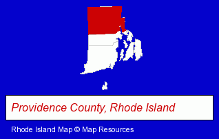
The Rhode Island counties map at upper right shows Providence County, highlighted in red. Use the menu below to display interactive maps of Cranston, either in a frame on this page or in full-screen mode.
Use the menu below to display categorized Cranston directories.
| Cranston Products and Services Directory | ||
|---|---|---|
| Accountants | Attorneys | Building Materials |
| Business Services | Home Improvement | Metal Finishing |
| Metals | Orthodontics Dentists | Restaurants |
Selected Cranston, Rhode Island Listings
These randomly selected Cranston listings provide some insight into the city's cultural environment and economic climate.- Electronic Equipment & Supplies Wholesale & Manufacturers
- Electronic Equipment & Supplies Retail
- Metal Stamping
- Auto Service & Repair
- Auto Body Repair & Painting
- Towing
- Auto Body Equipment & Supplies Retail
- Libraries
- Embroidery & Needlework
- Embroidery Service
- Orthodontics Dentists
- Health Information & Referral Services
- Bus Travel
- Bus Charter & Rental
- Food Products Wholesale & Manufacturers
- Seafood Restaurants
- Fish & Seafood Retail
- Fish & Seafood Wholesalers
- Industrial Equipment & Supplies Dealers
- Plastic & Plastic Products Wholesale & Manufacturers
- Clothing & Accessories Retail
- Jewelers
- Freight & Cargo Transport
- Freight Trucking
- Importers
- Textiles Wholesale & Manufacturers
- Fabrics Wholesale & Manufacturers
- Notions Wholesale & Manufacturers
- Yarn Wholesale & Manufacturers
- Coffee & Tea Shops
- Bakeries
- Baked Goods Wholesale & Manufacturers
- Health Information & Referral Services
- Wigs & Hairpieces Retail
- Health & Beauty Aids Retail
- Advertising
- Advertising & Promotional Product Dealers
- Advertising Specialties Wholesale & Manufacturers
- Advertising & Promotional Gifts
Nearby Rhode Island Cities and Towns *
- Pawtucket (4) - Pawtucket, Rhode Island information and maps.
- Providence (27) - Providence, Rhode Island solutions directory and maps.
- Smithfield (2) - Smithfield, Rhode Island information and maps.
- Warwick (14) - Warwick, Rhode Island demographics and directory.
Large and Mid-size Cities in Nearby States
- Fall River, Massachusetts (10) - Fall River, MA demographics and maps.
* Parenthesized numbers indicate economic activity levels.
Copyright © 2011-2026 RegionalDirectory.us. All rights reserved.