East Providence, Rhode Island Map and Directory
Regional Directory > States Menu > Rhode Island
 According to the United States Census Bureau, East Providence is a City that is located in Providence County, Rhode Island at 41.81 degrees North and 71.37 degrees West.
The city's time zone is America/New York, and the city's primary telephone area code is 401.
The land area of East Providence is about 13.24 square miles, whereas the water area of the city is about 3.31 square miles.
Providence County's land area is about 410 square miles, so the city occupies about 3.2 percent of the county's total land area.
According to the United States Census Bureau, East Providence is a City that is located in Providence County, Rhode Island at 41.81 degrees North and 71.37 degrees West.
The city's time zone is America/New York, and the city's primary telephone area code is 401.
The land area of East Providence is about 13.24 square miles, whereas the water area of the city is about 3.31 square miles.
Providence County's land area is about 410 square miles, so the city occupies about 3.2 percent of the county's total land area.
The Census Bureau estimates that East Providence had about 47,618 residents in 2019, which is approximately 3,597 people per square mile of land area.
According to recent American Community Survey data, the median household income in East Providence was about $59,142 per year.
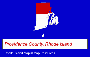
The Rhode Island counties map at upper right shows Providence County, highlighted in red. Use the menu below to display interactive maps of East Providence, either in a frame on this page or in full-screen mode.
Use the menu below to display categorized East Providence directories.
| East Providence Directory Page: | Attorneys |
|---|
Selected East Providence, Rhode Island Listings
These East Providence listings provide some insight into the city's cultural environment and economic climate.- Industrial Equipment & Supplies Dealers
- Cleaning Services
- Sewer & Drain Cleaning, Service & Repair
- Physicians & Surgeons
- Optometrists
- Optical Goods Retail
- Physicians & Surgeons
- Psychiatry Physicians
- Restaurants
- Steak Restaurants
- Restaurant Equipment & Services
- Restaurant Equipment & Supplies Retail
- Restaurant Equipment & Supplies Wholesale & Manufacturers
- Libraries
- Metals
- Medical Equipment & Supplies Retail
- Metal Stamping
- Textile & Apparel Fasteners
- Building Materials & Supplies Dealers
- Construction Machinery & Equipment Dealers
- Concrete Construction Equipment & Supplies
- Concrete Construction Forms & Accessories
- Speech & Hearing
- Hearing Aids & Assistive Devices Retail
- Optometrists
- Office Building & Industrial Cleaning Services
- Janitorial Services
- Interior Building Cleaning
- Schools
- Elementary & Secondary Education
- Elementary Schools
- Preschools & Kindergartens
- Private Schools
- Sporting Goods Dealers
- Chemicals Dealers
- Building & Home Construction
- Home Builders & Developers
- Signs Wholesale & Manufacturers
- Sun Rooms, Greenhouses, Solariums & Atriums Builders
- Schools
Nearby Rhode Island Cities and Towns *
- Cranston (9) - Cranston, Rhode Island demographics and directory.
- Pawtucket (4) - Pawtucket, Rhode Island information and maps.
- Providence (27) - Providence, Rhode Island solutions directory and maps.
- Smithfield (2) - Smithfield, Rhode Island information and maps.
- Warwick (14) - Warwick, Rhode Island demographics and directory.
Large and Mid-size Cities in Nearby States
- Attleboro, Massachusetts (7) - Attleboro, MA demographics and maps.
* Parenthesized numbers indicate economic activity levels.
Copyright © 2011-2026 RegionalDirectory.us. All rights reserved.