Wakefield, Rhode Island Map and Directory
Regional Directory > States Menu > Rhode Island
 According to the United States Census Bureau, Wakefield is a Census-designated Place that is located in Washington County, Rhode Island at 41.44 degrees North and 71.50 degrees West.
The place's time zone is America/New York, and the place's primary telephone area code is 401.
The land area of Wakefield is about 4.88 square miles, whereas the water area of the place is about 0.26 square miles.
Washington County's land area is about 329 square miles, so the place occupies about 1.5 percent of the county's total land area.
According to the United States Census Bureau, Wakefield is a Census-designated Place that is located in Washington County, Rhode Island at 41.44 degrees North and 71.50 degrees West.
The place's time zone is America/New York, and the place's primary telephone area code is 401.
The land area of Wakefield is about 4.88 square miles, whereas the water area of the place is about 0.26 square miles.
Washington County's land area is about 329 square miles, so the place occupies about 1.5 percent of the county's total land area.
The Census Bureau estimates that Wakefield had about 8,911 residents in 2014, which is approximately 1,826 people per square mile of land area.
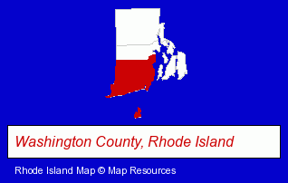
The Rhode Island counties map at upper right shows Washington County, highlighted in red. Use the menu below to display interactive maps of Wakefield, either in a frame on this page or in full-screen mode.
Use the menu below to display categorized Wakefield directories.
| Wakefield Products and Services Directory | |
|---|---|
| Building Materials | Home Improvement |
Selected Wakefield, Rhode Island Listings
These representative Wakefield listings provide some insight into the place's cultural environment and economic climate.- Electric & Electronic Equipment & Supplies
- Consumer Electronics Stores
- Electronic Equipment & Supplies Wholesale & Manufacturers
- Electric Equipment & Supplies Wholesale & Manufacturers
- Credit Unions
- Florists
- Greenhouses
- Security Systems & Services
- Visual Arts
- Artists & Art Studios
- Printing & Publishing
- Printing Services
- Commercial Printing
- Copying & Duplicating Services
- Blueprinting
- Travel Agents
- Travel Industry
- Cruises Travel Agents
- Airline Travel Agents
Nearby Rhode Island Cities and Towns *
- Cranston (9) - Cranston, Rhode Island demographics and directory.
- Middletown (3) - Middletown, Rhode Island information and maps.
- Newport (6) - Newport, Rhode Island demographics and maps.
- North Kingstown (2) - North Kingstown, Rhode Island information and maps.
- Providence (27) - Providence, Rhode Island solutions directory and maps.
- Warwick (14) - Warwick, Rhode Island demographics and directory.
* Parenthesized numbers indicate economic activity levels.
Copyright © 2011-2026 RegionalDirectory.us. All rights reserved.