Danville, Virginia Map and Directory
Regional Directory > States Menu > Virginia
 According to the United States Census Bureau, Danville is a City that is located in Danville City County, Virginia at 36.59 degrees North and 79.40 degrees West.
The city's time zone is America/New York, and the city's primary telephone area code is 804.
The land area of Danville is about 42.97 square miles, whereas the water area of the city is about 0.98 square miles.
Danville City County's land area is about 43 square miles, so the city occupies about 99.9 percent of the county's total land area.
According to the United States Census Bureau, Danville is a City that is located in Danville City County, Virginia at 36.59 degrees North and 79.40 degrees West.
The city's time zone is America/New York, and the city's primary telephone area code is 804.
The land area of Danville is about 42.97 square miles, whereas the water area of the city is about 0.98 square miles.
Danville City County's land area is about 43 square miles, so the city occupies about 99.9 percent of the county's total land area.
The Census Bureau estimates that Danville had about 40,044 residents in 2019, which is approximately 932 people per square mile of land area.
According to recent American Community Survey data, the median household income in Danville was about $37,203 per year.
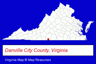
The Virginia counties map at upper right shows Danville City County, highlighted in red. Use the menu below to display interactive maps of Danville, either in a frame on this page or in full-screen mode.
Use the menu below to display categorized Danville directories.
| Danville Products and Services Directory | |
|---|---|
| Clothing Stores | Schools |
Selected Danville, Virginia Listings
These representative Danville listings provide some insight into the city's cultural environment and economic climate.- Clothing & Accessories Retail
- Jewelers
- Jewelry Repair
- Watch Service & Repair
- Jewelry Brokers & Buyers
- Building Materials & Supplies Dealers
- Industrial Equipment & Supplies Dealers
- Cutting Tools Wholesale & Manufacturers
- Cutting Tools
- Attorneys
- Attorneys
- Appeals Attorneys
- Civil Law Attorneys
- Accident Attorneys
- Party Equipment & Supplies Sales & Rental
- Packaging & Shipping Materials Retail
- Janitorial Equipment & Supplies Retail
- Disposable Products Retail
- Lawn & Garden Equipment & Supplies Retail
- Sign Dealers
- Signs Wholesale & Manufacturers
- Commercial Signs
- Sign Installation & Hanging
- Clothing & Accessories Retail
- Shoe Stores
- Security Systems & Services
- Alarm System Dealers
- Fire Alarm Sales & Service
- Burglar Alarm Systems & Monitoring
- Accountants
- Public Accountants
- Certified Public Accountants
Nearby Virginia Cities and Towns *
- Blacksburg (4) - Blacksburg, Virginia information and maps.
- Charlottesville (28) - Charlottesville, Virginia solutions directory and maps.
- Harrisonburg (12) - Harrisonburg, Virginia demographics and directory.
- Lynchburg (11) - Lynchburg, Virginia demographics and directory.
- Martinsville (3) - Martinsville, Virginia information and maps.
- Roanoke (27) - Roanoke, Virginia solutions directory and maps.
- Staunton (5) - Staunton, Virginia demographics and maps.
* Parenthesized numbers indicate economic activity levels.
Copyright © 2011-2026 RegionalDirectory.us. All rights reserved.