Wellington, Kansas Map and Directory
Regional Directory > States Menu > Kansas
 According to the United States Census Bureau, Wellington is a City that is located in Sumner County, Kansas at 37.27 degrees North and 97.37 degrees West.
The city's time zone is America/Chicago, and the city's primary telephone area code is 620.
The land area of Wellington is about 7.31 square miles, whereas the water area of the city is about 0.89 square miles.
Sumner County's land area is about 1,182 square miles, so the city occupies about 0.6 percent of the county's total land area.
According to the United States Census Bureau, Wellington is a City that is located in Sumner County, Kansas at 37.27 degrees North and 97.37 degrees West.
The city's time zone is America/Chicago, and the city's primary telephone area code is 620.
The land area of Wellington is about 7.31 square miles, whereas the water area of the city is about 0.89 square miles.
Sumner County's land area is about 1,182 square miles, so the city occupies about 0.6 percent of the county's total land area.
The Census Bureau estimates that Wellington had about 7,662 residents in 2019, which is approximately 1,048 people per square mile of land area.
According to recent American Community Survey data, the median household income in Wellington was about $44,596 per year.
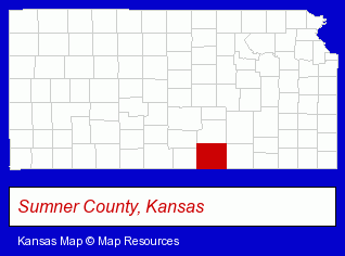
The Kansas counties map at upper right shows Sumner County, highlighted in red. Use the menu below to display interactive maps of Wellington, either in a frame on this page or in full-screen mode.
Use the menu below to display categorized Wellington directories.
| Wellington Directory Page: | Banks |
|---|
Selected Wellington, Kansas Listings
These Wellington listings provide some insight into the city's cultural environment and economic climate.- Veterinarians
- Animal Hospitals
- Pet Sitting & Day Care
- Investment Services
- Investments
- Investment Securities
- Auto Service & Repair
- Jewelers
- Aircraft Parts & Equipment Retail
- Government Contractors
- Aircraft Parts & Equipment Retail
- Fabricated Structural Metal Manufacturers
- Mortgages
- Credit Unions
- Attorneys
- Bankruptcy Services
- Charitable & Nonprofit Organizations
- Electric Companies
- Schools
- Elementary & Secondary Education
- Elementary Schools
- Public Schools
- Educational Administration
- Printing Services
- Commercial Printing
- Newspaper Publishers
Nearby Kansas Cities and Towns *
- Andover (2) - Andover, Kansas information and maps.
- Derby (1) - Derby, Kansas information and maps.
- Hutchinson (9) - Hutchinson, Kansas demographics and directory.
- Lindsborg (1) - Lindsborg, Kansas information and maps.
- Newton (2) - Newton, Kansas information and maps.
- Salina (11) - Salina, Kansas demographics and directory.
- Wichita (109) - Wichita, Kansas products & services directory.
* Parenthesized numbers indicate economic activity levels.
Copyright © 2011-2026 RegionalDirectory.us. All rights reserved.