Paducah, Kentucky Map and Directory
Regional Directory > States Menu > Kentucky
 According to the United States Census Bureau, Paducah is a City that is located in McCracken County, Kentucky at 37.08 degrees North and 88.60 degrees West.
The city's time zone is America/Chicago, and the city's primary telephone area code is 364.
The land area of Paducah is about 20.17 square miles, whereas the water area of the city is about 0.44 square miles.
McCracken County's land area is about 249 square miles, so the city occupies about 8.1 percent of the county's total land area.
According to the United States Census Bureau, Paducah is a City that is located in McCracken County, Kentucky at 37.08 degrees North and 88.60 degrees West.
The city's time zone is America/Chicago, and the city's primary telephone area code is 364.
The land area of Paducah is about 20.17 square miles, whereas the water area of the city is about 0.44 square miles.
McCracken County's land area is about 249 square miles, so the city occupies about 8.1 percent of the county's total land area.
The Census Bureau estimates that Paducah had about 24,865 residents in 2019, which is approximately 1,233 people per square mile of land area.
According to recent American Community Survey data, the median household income in Paducah was about $39,266 per year.
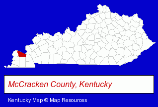
The Kentucky counties map at upper right shows McCracken County, highlighted in red. Use the menu below to display interactive maps of Paducah, either in a frame on this page or in full-screen mode.
Use the menu below to display categorized Paducah directories.
| Paducah Products and Services Directory | ||
|---|---|---|
| Attorneys | Auto Engine Services | Auto Service |
| Building Materials | Business Services | Dentists |
| Home Improvement | Metals | Physicians |
| Printing and Publishing | Skin Care Products | Visual Arts |
Selected Paducah, Kentucky Listings
These randomly selected Paducah listings provide some insight into the city's cultural environment and economic climate.- Swimming Pools Manufacturers & Distributors
- Dermatology Physicians & Surgeons
- Skin Care Products
- Financial Services
- Personal Financial Services
- Check Cashing Services
- Veterinarians
- Animal Health
- Interior Decorators & Designers
- Clothing & Accessories Retail
- Jewelers
- Lodging
- Hotels
- Bed & Breakfasts
- Auctions
- Auctioneers & Auction Houses
- Charitable & Nonprofit Organizations
- Visual Arts
- Art Galleries & Dealers
Nearby Kentucky Cities and Towns *
- Bowling Green (11) - Bowling Green, Kentucky demographics and directory.
- Hopkinsville (1) - Hopkinsville, Kentucky information and maps.
- Louisville (92) - Louisville, Kentucky products & services directory.
- Mayfield (2) - Mayfield, Kentucky information and maps.
- Murray (2) - Murray, Kentucky information and maps.
- Owensboro (6) - Owensboro, Kentucky demographics and maps.
* Parenthesized numbers indicate economic activity levels.
Copyright © 2011-2026 RegionalDirectory.us. All rights reserved.