Westfield, Massachusetts Map and Directory
Regional Directory > States Menu > Massachusetts
 According to the United States Census Bureau, Westfield is a City that is located in Hampden County, Massachusetts at 42.13 degrees North and 72.75 degrees West.
The city's time zone is America/New York, and the city's primary telephone area code is 413.
The land area of Westfield is about 46.26 square miles, whereas the water area of the city is about 1.06 square miles.
Hampden County's land area is about 617 square miles, so the city occupies about 7.5 percent of the county's total land area.
According to the United States Census Bureau, Westfield is a City that is located in Hampden County, Massachusetts at 42.13 degrees North and 72.75 degrees West.
The city's time zone is America/New York, and the city's primary telephone area code is 413.
The land area of Westfield is about 46.26 square miles, whereas the water area of the city is about 1.06 square miles.
Hampden County's land area is about 617 square miles, so the city occupies about 7.5 percent of the county's total land area.
The Census Bureau estimates that Westfield had about 41,204 residents in 2019, which is approximately 891 people per square mile of land area.
According to recent American Community Survey data, the median household income in Westfield was about $67,862 per year.
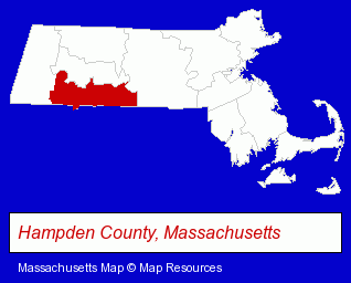
The Massachusetts counties map at upper right shows Hampden County, highlighted in red. Use the menu below to display interactive maps of Westfield, either in a frame on this page or in full-screen mode.
Use the menu below to display categorized Westfield directories.
| Westfield Products and Services Directory | ||
|---|---|---|
| Attorneys | Dentists | Financial Services |
| Health Clubs and Gyms | Home Improvement | |
Selected Westfield, Massachusetts Listings
These randomly selected Westfield listings provide some insight into the city's cultural environment and economic climate.- Building Materials & Supplies Wholesale & Manufacturers
- HVAC Equipment & Supplies Dealers
- Plumbing & Heating Supplies Retail
- Heating Equipment Parts & Supplies Dealers
- Auto Alarms & Security Systems
- Moving & Storage
- Movers
- Household Goods & Furniture Storage
- Trailer Renting & Leasing
- Storage Trailers & Containers
- Endodontics Dentists
- Movers
- Florists
- Medical Equipment & Supplies Retail
- Machine Shops
- Printing & Publishing
- Printing Services
- Painting Contractors
- Door & Door Frame Dealers
- Ceramic Tiles
- Floor Resurfacing Materials
- Utilities
- Electric Companies
- Bicycle Repair & Maintenance
- Bicycle Rental
- General Real Estate
- Real Estate Agencies & Brokerage
- Real Estate Appraisers
- Escrow Services
- Real Estate Buyer Brokers
- Animal Hospitals
- Railroads
- Jewelers
- Jewelry Repair
- Outdoor Sports & Recreation
- Importers
- Hunting
- Guns Wholesale & Manufacturers
- Sports & Recreation Facilities
- Health Clubs & Gyms
- Heating Contractors
- Air Conditioning Contractors
- Heating & Ventilating Contractors
- Sheet Metal Contractors
- Bars & Pubs
- Engineering Equipment & Supplies
- Industrial Engineers
- Carpet & Rug Dealers
- Ceramic Tiles
- Floor Laying Equipment & Supplies
- Vinyl Flooring Retail
- Chambers of Commerce
- Other Schools & Instruction
- Driver Training
- Defensive Driving Instruction
Nearby Massachusetts Cities and Towns *
- Chicopee (2) - Chicopee, Massachusetts information and maps.
- East Longmeadow (1) - East Longmeadow, Massachusetts information and maps.
- Hadley (2) - Hadley, Massachusetts information and maps.
- Holyoke (4) - Holyoke, Massachusetts information and maps.
- Northampton (8) - Northampton, Massachusetts demographics and maps.
- South Hadley (2) - South Hadley, Massachusetts information and maps.
- Springfield (18) - Springfield, Massachusetts solutions directory and maps.
* Parenthesized numbers indicate economic activity levels.
Copyright © 2011-2026 RegionalDirectory.us. All rights reserved.